Visual Materials
Aerial views of the Los Angeles River during flooding
Image not available
You might also be interested in
Image not available
Los Angeles County Flood Control Research
Manuscripts
The two bound typescripts contain research regarding flooding in Los Angeles County that was prepared by J. W. Reagan, Consulting Engineer for the Corps of Engineers' Engineer Office and Chairman of the Committee of Menaced and Flooded Areas. The report contains statements of various California residents regarding their experience with floods in the Los Angeles area. Their narratives include damage caused by floods as well as work done to prevent flooding in their area including dams and river rerouting. The research chiefly covers floods caused by the Los Angeles River and the San Gabriel River from the 1770s to 1913. The report also includes precipitation data from 1849 to 1913 for parts of southern California.
mssHM 66796
Image not available
Tentative report to the Board of Supervisors of the Los Angeles County Flood Control District
Manuscripts
The report, written by J. W. Reagan, Chief Engineer of the Los Angeles County Flood Control District, was presented to the Board of Supervisors of the Los Angeles County Flood Control District, February 7, 1924. The report covers the work previously done to prevent flooding in southern California; precipitation data; past floods in southern California; plans for conservation of water; the Los Angeles water supply; and future plans for flood control. The report chiefly deals with floods caused by the Los Angeles River and the San Gabriel River. Also included with the report is a list of cost estimates for the proposed flood control work and twenty pullout maps.
mssHM 66799
Image not available
Photograph album containing landscape views of Los Angeles and surrounding counties, and city views of Los Angeles
Visual Materials
The collection consists of photographs (the majority of which are housed in two photograph albums), negatives, published material, and ephemera that depict locations throughout California and the Western United States. Many of these were locations where Frank Rolfe, a geologist, worked on various surveys, including the Los Angeles aqueduct survey. The collection contains two photograph albums: one depicts the initial Los Angeles aqueduct survey, the second contains photographs of Los Angeles (central Los Angeles and neighborhoods where Rolfe and his wife lived), the San Gabriel Valley and other locations in Los Angeles County (Devil's Gate Dam, the San Gabriel Mountains, the St. Francis Dam and San Francisquito Canyon), San Bernardino County (the San Bernardino Mountains, Big Bear Lake), Riverside County (the Coachella Valley, Tahquitz Canyon, the Temescal Valley, Riverside, the San Jacinto Mountains), Kern County, and commercially produced images of Yosemite. Boxes 3 and 4 contain negatives; viewing of the negatives must be arranged with the Curator of Photographs. The negatives depict street scenes in central Los Angeles, including the wrecking of the Temple Block, the Amestoy Block, the Hall of Records, and Bunker Hill. Also included are views of the West Adams neighborhood; houses where Rolfe and his wife lived in the 1920s and 30s; the snowstorm of 1932; and the 1920 Inglewood earthquake. The collection also includes images of Hollywood and vicinity (including a number of photographs of the Mulholland Dam and images of Brentwood and Bel Air); Santa Monica (including the Santa Monica Mountains and Decker Canyon); Santa Catalina Island; north Los Angeles County (including the San Fernando and Santa Clarita valleys, the ruins of the Saint Francis Dam and San Francisquito Canyon, and the golden spike celebration at Lang); the San Gabriel Valley (including many views of the San Gabriel Mountains); Orange County (including Modjeska's home, Santiago Canyon, San Juan Capistrano, the Puente hills, and Santa Ana Canyon); San Diego County; San Bernardino County (including a number of photographs of mining camps, including Ivanpah and Camp Roach; construction of the Ludlow and Southern Railway; and mining operations, such as the Bagdad Chase Mine and the Bagdad Mining and Milling Company); Riverside County (including the Temescal Tin Mine, Temescal and the Temescal Valley, Hog Lake, the San Jacinto River, Mount San Jacinto, and Idyllwild); Ventura County; Kern County (images of the Kern River); Inyo County; Yosemite; northern California (including Stanford and Susie Lake); Nevada (Truckee River dam projects); Oregon; Washington; Utah; Glacier Park, Montana; people (Rolfe, his family and friends); and miscellaneous photographs (a number of desert views, mostly Southern California). The collection also contains commercial photographs of the Rolfe family, many in carte-de-visite format. The ephemerial materials consist of a letter written in 1862 from Sutter Creek by Rolfe's father Ovid to his brother Alfred in Dorchester, Massachusetts; biographical sketches of members of the Rolfe family; clippings compiled by Rolfe; Rolfe's high school and college diplomas; card files on Rolfe family history, covered wagons in Los Angeles, and Temescal history; and negative books.
photCL 400 volume 12
Image not available
Map of the Basin of San Fernando. Los Angeles Co., Cal
Rare Books
A blueprint of a map designed to show water table levels within the San Fernando Valley. Sixteen wells were examined with depths between 818 feet (central valley) and 404 feet (at the narrows). Rancho El Escorpion (Canoga Park) on the west, Verdugo wash and City of Los Angeles on the east and south, Sylmar area on the north. Area of Hollywood and Beverly Hills noted as "Cahuenga Valley." Routes of Pacoima and Tujunga Washes reinforces Los Angeles City claim to water underlying the San Fernando Valley. "L. Friel, C. E." Relief: hachures. Projection: Plane. Printing Process: Blueprint copy. Verso Text: MS notes: San Fernando Valley 446663.
446663
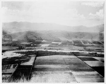
Los Angeles, Looking North from Elysian Park showing Los Angeles River and Mt. Washington
Visual Materials
A view looking from Elysian Park towards the San Gabriel Mountains with farmlands, farmhouses and the Los Angeles River.
photCL Pierce 00853
Image not available
Los Angeles – Aerial views, 1969
Visual Materials
This is a collection primarily of negatives and photographic prints depicting the growth of Santa Monica and Los Angeles, California, from 1860s to 1980s. Many views are cityscapes or street views, showing buildings, storefronts, homes and roads, and documenting the use of railroads, trolleys, streetcars, and automobiles. There are many card photographs by early professional photographers, and also a number of snapshots made by amateurs, some in personal photo albums. The collection's scope also includes early views of many other communities in Southern California (and a few in other states); the beginnings of aviation in Santa Monica, including the first Douglas Aircraft Company buildings; a photo album of residents in Topanga Canyon, ca. 1913; automobile racing in Los Angeles and Santa Monica, 1920s; maritime views; a photo album of U.S. troops in France during World War I; a 1949 real estate development in Apple Valley, California, and others. Besides photographs, a portion of the collection consists of scarce publications and historical ephemera, primarily related to Santa Monica and Los Angeles, including brochures, advertising cards, menus, event programs and other materials. Highlights of the Santa Monica images are aerial views of the buildings along the coast and pier (1920s); several views of the Arcadia Hotel (1880s); the Long Wharf and adjoining railroad and train depot; the first bath houses on the beach; the beach club culture of the 1920s and 1930s; the amusement piers of Santa Monica, Ocean Park and Venice; and the beginnings of the Douglas Aircraft Company. There is a large set of promotional photographs made late 1920s-1930s by Powell Press Service depicting people enjoying Santa Monica's beaches, clubs and outdoor recreation. An important subset within the collection is 407 negatives made ca. 1890 - 1908 by Los Angeles historian and amateur photographer George W. Hazard (1842-1914). Hazard travelled around Los Angeles and vicinity photographing the adobes, houses, streets and storefronts that told the early history of the city. Many of Hazard's negatives have handwritten identifications, naming streets, former homeowners, ranchos, and other historical details. There are a large number of cabinet cards and other card-mounted prints and stereographs. There are 1,264 stereograph prints, highlighted by the works of photographic pioneers William M. Godfrey, Francis Parker, Hayward & Muzzall, and Carleton Watkins. Other formats represented are: glass and film negatives; panoramic prints; 7 photograph albums, photographic postcards, 20th-century color prints and transparencies; and a small number of tintypes, cyanotypes and a set of chromolithographs.
photCL 555