Manuscripts
Up river from Mile 1.2. Stillwater Canyon. The tiny knob on the far point is the City Hall. Close to the location of Nims No. 26 of 1889, May 29, and Cogswell photo Plate 46A in Stone's "Canyon Country"

You might also be interested in
Lower Green River. Similar formations to those in Cogswell photo shown in Pl. 46A of "Canyon Country," Julius F. Stone, and Nims photo 26
Manuscripts
mssMarston papers V005/0003

26. Box Wells, Green River. Brown-Stanton party. Up from approximately Mile 1.2. Same location as Cogswell photo, Plate 46A
Manuscripts
mssMarston papers V005/0007

Up Marble Canyon from foot of Sheerwall Rapid at approximate location of Nims photo 170 of 1889, July 11
Manuscripts
mssMarston papers V045/0049
Image not available
Nims (Wolverton, Enid) Description of Nims Photos of 1889 Stanton Trip
Manuscripts
Professional and personal papers of Otis R. Marston and his collection of the materials on the history of Colorado River and Green River regions.
mssMarston papers
Image not available
Stillwater Canyon
Manuscripts
Professional and personal papers of Otis R. Marston and his collection of the materials on the history of Colorado River and Green River regions.
mssMarston papers
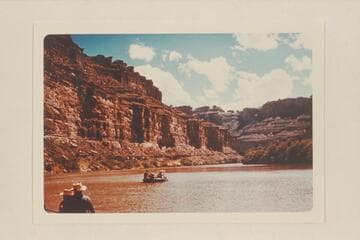
![Down Green River. Mile 1.1-1.2?? which does not check with the other photo showing the same location. Stillwater Canyon [on reverse: view downstream, right bank. Near duplicate McCormick Photo #4]](/_next/image?url=https%3A%2F%2Frail.huntington.org%2FIIIF3%2FImage%2F22APN4ID6ZW7%2Ffull%2F%5E360%2C%2F0%2Fdefault.jpg&w=750&q=75)