Visual Materials
This map shows the powerhouses and main reservoirs on the Big Creek Project
You might also be interested in
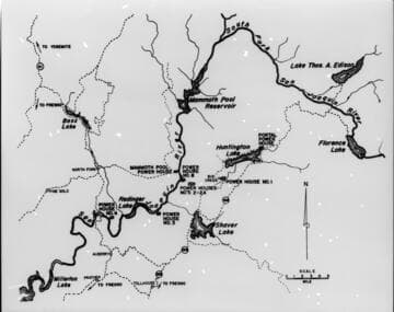
Map of Big Creek area
Visual Materials
[Map of Big Creek area - reservoirs and powerhouses shown, but not flow-lines, tunnels, or penstocks]
photCL SCE 06 - 73016

This 1922 map shows the proposed ultimate development of the Big Creek Project to a size even larger than that first envisioned by John Eastwood
Visual Materials
This 1922 map shows the proposed ultimate development of the Big Creek Project to a size even larger than that first envisioned by John Eastwood. Still later plans added more powerhouses on the South Fork of the San Joaquin, but none were built before the depression ended work. Today, the Balsam Meadows Plant is near the site of old Powerhouse #5. Pg. 103.
photCL SCE 11 - 00208
Image not available
Construction of Big Creek Powerhouse 1 and 2; construction of Huntington Lake Dams 1, 2, and 3, and Dam 4, power tunnels, intakes, etc
Visual Materials
Construction of Big Creek Powerhouse 1 and 2 and Construction of Huntington Lake Dams 1, 2, 3, and 4. Views of tunnels, intakes, dams, reservoirs, lakes, and powerhouses in various stages of construction. Photographer: Stone & Webster Engineering Corporation.
photCL SCE

C1.3 - Maps - Outline map of Big Creek Territory (Dennis) showing cross-sections of tunnels at Big Creek
Visual Materials
C1.3 - Maps - Outline map of Big Creek Territory (Dennis) [showing cross-sections of tunnels at Big Creek]
photCL SCE 02 - 16932

Birdseye View. Big Creek-San Joaquin River. Water Power Development of the Southern California Edison Co
Visual Materials
"Birdseye View, Big Creek - San Joaquin River, Water Power Development of the Southern California Edison Co." Map/drawing shows the plans SCE had to expand the Big Creek project to 18 powerhouses, producing 1,460,000 kilowatts through 1943. The Depression, the construction of Hoover Dam, and World War II killed the ultimate completion of the planned expansion.
photCL SCE 12 - 00202

Map of Big Creek No. 8 Development for Val. Dept
Visual Materials
Map of Big Creek No. 8 Development for Val. Dept. - includes location of Powerhouses 8, 2, & 2a, Dams 5 & 6, Tunnel 8, Camps 7, 31, 32, 33, & 42, penstock, transmission lines, roads and railroads.
photCL SCE 02 - 16223