Visual Materials
Popular map of Big Creek Layout "Pagett"

You might also be interested in

Elevation diagram of the Big Creek Facilities Layout
Visual Materials
Elevation diagram of the Big Creek Facilities Layout
photCL SCE 02 - 19434
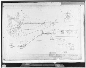
C1.1 - Charts miscellaneous - Big Creek #3
Visual Materials
C1.1 - Charts miscellaneous - Big Creek #3 - Drawing - general layout of project - Plan & Profile.
photCL SCE 02 - 11120

"We Call It Big Creek"
Visual Materials
["We Call It Big Creek" - Map-graphic showing layout of the Big Creek hydroelectric system)]
photCL SCE 06 - 72129

C1.3 - Maps - Map for the Big Creek project
Visual Materials
C1.3 - Maps - Map for the Big Creek project - Exhibit "B" for SCE's hydroelectric development on the San Joaquin River. Includes PH 6 and PH 7 which were never built..
photCL SCE 02 - 05451
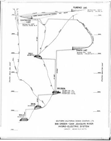
Big Creek General - Diagramatic elevation profile map of Big Creek
Visual Materials
Big Creek General - Diagramatic [elevation profile] map of Big Creek - San Joaquin River Hydro-electric System.
photCL SCE 02 - 27863

C1.3 - Maps - Outline map of Big Creek Territory (Dennis) showing cross-sections of tunnels at Big Creek
Visual Materials
C1.3 - Maps - Outline map of Big Creek Territory (Dennis) [showing cross-sections of tunnels at Big Creek]
photCL SCE 02 - 16932