Visual Materials
Map

You might also be interested in

C1.3 - Maps
Visual Materials
C1.3 - Maps - Profile map of the "Ultimate Projected" hydro-electric development on the San Joaquin River for Edison's Big Creek Project
photCL SCE 02 - 08450
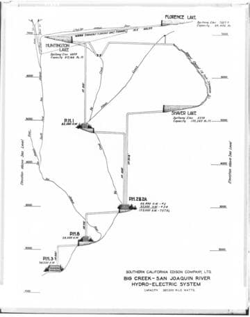
Big Creek General - Diagramatic elevation profile map of Big Creek
Visual Materials
Big Creek General - Diagramatic [elevation profile] map of Big Creek - San Joaquin River Hydro-electric System.
photCL SCE 02 - 27863

C1.3 - Maps
Visual Materials
C1.3 - Maps - Relief map of the "Ultimate Projected" hydro-electric development on the San Joaquin River for Edison's Big Creek Project. Padget conception.
photCL SCE 02 - 08465

C1.3 - Maps
Visual Materials
C1.3 - Maps - Hydro Electric Development of the Big Creek Project
photCL SCE 02 - 07452

Colorado River - Map of western states showing plans for hydro-electric development of the Colorado River
Visual Materials
Colorado River - Map of western states showing plans for hydro-electric development of the Colorado River - Boulder Canyon Unit, Diamond Creek Unit, Marble Canyon Unit and Glen Canyon Unit.
photCL SCE 02 - 05943

C1.3 - Maps - Map for the Big Creek project
Visual Materials
C1.3 - Maps - Map for the Big Creek project - Exhibit "B" for SCE's hydroelectric development on the San Joaquin River. Includes PH 6 and PH 7 which were never built..
photCL SCE 02 - 05451