Visual Materials
East end of Apalabasa St. taken from [Avila Street]

You might also be interested in

Jewel Stables east end of Apalabasa St
Visual Materials
View of the Jewel Stables on Apablasa Street in Old Chinatown, Los Angeles, with wagons, men, and a chicken visible. The shadow of the camera and the photographer are visible in the foreground.
photCL 502 (43)

Jewel Stables on Apalabasa St
Visual Materials
View of the Jewel Stables on Apablasa Street in Old Chinatown, Los Angeles.
photCL 502 (42)

North of Apalabasa & east of Alameda St
Visual Materials
View of buildings backing up to a vacant dirt lot north of Apablasa Street and east of Alameda Street near Old Chinatown, Los Angeles. There is advertising on the wall of one of the buildings and billboards along a fence. Lumber is stacked in the lot.
photCL 502 (9)
Image not available
East end of Apalabasa St. taken from A[?]
Visual Materials
This collection contains 131 black-and-white photographs (including some duplicates) of views of building exteriors and streets scenes in Old Chinatown and neighboring residential and industrial areas of downtown Los Angeles, California, that were taken prior to the demolition of the area beginning on December 23, 1933, to make way for the Los Angeles Union Station railroad terminal. The photographs consist of eye-level street views focused on the area of downtown Los Angeles, around Apablasa Street (spelled Apalabasa or Apalabassa on the images), that was bordered by Alameda Street to the west, Aliso Street to the south, Date and College Streets to the north, and Lyon to the east. The views include images of industrial and commercial areas; retail storefronts; warehouses; manufacturing; utility and railroad buildings; houses and apartments with balconies; dirt streets and alleys; children; automobiles; and dilapidated and vacant buildings. The signage on retail buildings often reflects the Chinese and Hispanic heritage of residents and shop owners in the area. The photographer is unidentified, but presumably the photographs were created to aid in planning for the project, perhaps as part of the process of determining property valuation.
photCL 502

Looking east along Ramirez St. from Avila St
Visual Materials
View of storage tanks and silos of the Los Angeles Gas and Electric Corporation gas plant, and wooden sheds viewed from Ramirez Street and Avila Street near Old Chinatown in Los Angeles.
photCL 502 (23)
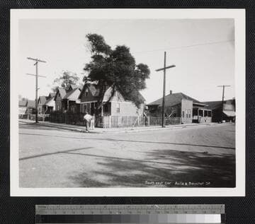
South east cor. Avila & Bauchet St
Visual Materials
View of houses with fenced-in yards and trees, as well as two boys standing at center and a business at the far right viewed from the corner of Avila Street and Bauchet Street near Old Chinatown in Los Angeles.
photCL 502 (102a)