Opening Hours
Daily: 10 A.M.–5 P.M.
Closed on Tuesdays
1151 Oxford Road
San Marino, CA 91108
Daily: 10 A.M.–5 P.M.
Closed on Tuesdays
1151 Oxford Road
San Marino, CA 91108

Image not available
Visual Materials
Kashnor notes, "A fine map of the North-West Coast, the only one issued in this form which shows the track of La Perouse to California and up the coast to Bering's Bay." Locates Vancouver Island and the Georgian Strait with the note "which must be the Sea of the West." Greenland shown attached to North American mainland. This map is a later issue of 105:043 and 105:261. Added explorers routes. Prime meridian: London. Relief: pictorial. Projection: Mercator. Printing Process: Copper engraving. Verso Text: MS note: 191.
093:191 M
Image not available
Visual Materials
Kashnor notes, "A fine map of the North-West coast, locating many points from California to Alaska, including San Francisco, San Gabriel, San Juan and San Diego, the Columbia River and the Russian Factories. It is also a correct map of Australia and the South Seas." A very large map. Cartouche - carved monolith.. Prime meridian: GM. Relief: hachures. Projection: Mercator. Printing Process: Engraving/ Etching?. Other Features: Cartouche. Verso Text: MS notes 172 4 sheets. Tags "World S. W." (typ.).
093:172 M
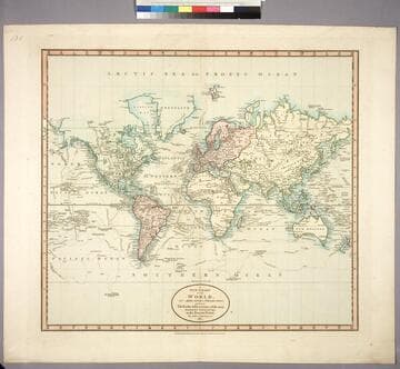
Visual Materials
Kashnor notes,"Shows the coast to Icy Cape. Locates Port Vancouver, San Francisco, Santa Clara, Santa Barbara, Monterey and Salt Lake; also shows the tracks of Cook and Vancouver." See also 105:260, an earlier duplicate version of this map dated 1801. Ms note: 1811. Prime meridian: London. Relief: pictorial. Projection: Mercator. Printing Process: Copper engraving. Verso Text: MS note: 189.
093:189 M
Image not available
Visual Materials
Kashnor notes, "Gives a map of the North-West Coast, and shows the tracks of Vancouver, Cook, and La Perouse." See 105:233M for another copy. Printed No. 1 pasted upper right corner.. Prime meridian: GM. Relief: pictorial. Graphic Scale: No. Projection: Mercator. Printing Process: Copper engraving. Verso Text: MS. note: 24.
093:024 M
Image not available
Visual Materials
Kashnor notes, "A scarce and interesting map of the North-West Coast, showing the tracks of Cook and La Perouse up the coast of Alaska. Locates Fort Vancouver, and the Columbia River, Drake's Harbour and other towns on the California coast." Seven Compass Roses, variable latitude and longitude scales with explanation for use. Cartouche flanked by two mariners, possibly Cook and Vancouver.. Prime meridian: GM. Relief: pictorial. Graphic Scale: Miles, leagues.. Projection: Mercator. Printing Process: Copper engraving. Other Features: CartoucheCompass Roses. Verso Text: MS. notes: Tanner Speenhandand; No. 8; John Othen, 1870; Fred Boyer, 3437529609165; 27; 210/56; 350/58.
093:008 M
Image not available
Visual Materials
Kashnor notes, "Shows Cook's tracks in the South Seas and to the North-West Coast of America. Locates Drake's Harbour and New Albion." Atlas reference from Rosenthal. Also shows tracks of Bouganville in 1768, Byron in 1765. See also 105:019M for an earlier version of this map (1781). Numeral 2 in upper right, lower right outside neatline. Also 093-190S for later version. Compass rose lower center.. Prime meridian: London. Relief: pictorial. Graphic Scale: Sea leagues 20 in a Degree. Projection: Mercator. Printing Process: Copper engraving. Other Features: Art Work. References: Phillips (A)659-2; Marshyall I-301-2-1 [from Rosenthal 1996]. Verso Text: MS. note:93 62; II.
093:062 M