Visual Materials
New Map of the City of Philadelphia, reduced by Photography from a large survey made expressly for the City and corrected from Plans and Draughts in the Department of Surveys, by John. H. Dye, Draughtsman and Surveyor
You might also be interested in

Plan of the City of Philadelphia, the Capital of Pennsylvania, from an Actual Survey by Benjamin Easburn, Surveyor-General 1776
Visual Materials
Kashnor notes, " A very fine and exceedingly rare plan, giving the names of all the wharves along the sea-front, and indicating the various public buildings, Churches, meeting-houses, &c. The plans extend north to Margaretta St. at Allen and Salter's Wharf, with Clifton's, Moyer's, and Huston's wharves beyond; south it reaches to Wicaco Lane and the old Fort, and west there is only shown Pennsylvania Hospital and six houses on Eighth Street." Relief: no. Graphic Scale: Feet. Projection: Plane. Watermark: Seal. Printing Process: Copper engraving. Verso Text: MS notes: 105/137 49.
105:137 M
Image not available
Correct Plan of the Environs of Quebec, and of the Battle fought on the 13th. September, 1759: Together with a particular detail of The French Lines and Batteries, And also of the Encampments, Batteries and Attacks of the British Army, And the Investiture of that City under the Command of Vice Admiral Saunders, Major General Wolfe, Brigadier General Monckton, and Brigadier General Townshend. Drawn from the Original Surveys taken by the Engineers of the Army. Engraved by Thomas Jefferys, Geographer to His Majesty
Visual Materials
Kashnor notes, "with the exceedingly rare slip of the Plains of Abraham, showing the later movements of the armies, a fine impression of the rarest battle plan of the Old French War." Kashnor dates [1759]. Submap: Foldover insert on lower left labeled "Second plate".. Relief: hachures. Graphic Scale: Miles, feet. Projection: Plane. Printing Process: Copper engraving. Other Features: Sub-maps. Verso Text: MS note: 328.
093:328 M
Image not available
Chart of Buffalo Harbor and Head of Niagara River with the Outlet of Lake Erie Compiled in the Bureau of Topl. Engrs. from the surveys of Capt. W. G. Williams, T. E. with recent corrections and additions by Capt. L. C. Woodruff, T. E. 1856
Visual Materials
Kashnor notes, "Also a good plan of the City of Buffalo." Seal of "Survey of the Lakes" 1857.. Relief: no. Graphic Scale: Miles, feet. Projection: Plane. Printing Process: Engraving. Verso Text: MS note: 476.
093:476 M
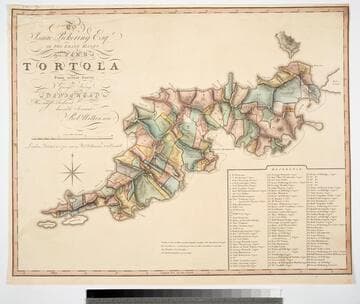
To Isaac Pickering Esqr of Fox Lease Hants this Plan of Tortola From actual Survey by George King is dedicated by His most obedient humble Servant Robt. Wilkinson
Visual Materials
Kashnor notes, "With a list of 104 plantations indicated on plan, with owners names." Pickering held the westernmost point of this island in the British Virgin Islands. Reference table listing owners and parcel numbers. MS note: 843 29. Prime meridian: GM. Relief: hachures. Graphic Scale: Miles, chains. Projection: Plane. Printing Process: Copper engraving. Verso Text: MS note: 843.
093:843 M

Harbour of Charles Town in South Carolina from the Surveys of Sr. Jas. Wallace Captn in his Majesty's Navy & Others. with a View of the Town from the South Shore of Ashley River
Visual Materials
Kashnor notes, "One of the rarest views of Charles Town, in colours, it is very fine, and has the appearance of a water-colour drawing." View of city from south shore of Ashley River a fine water colored insert.. Relief: pictorial. Graphic Scale: Miles, statute & nautical. Projection: Plane. Printing Process: Copper engraving. Other Features: Art Work. Verso Text: MS note: 71.
093:071 M
Image not available
Map of the British Settlement in Honduras From the actual Surveys of N. C. Du Vernay, Surveyor, made in and between the years 1808 and 1816
Visual Materials
Kashnor notes, "A rare map, published only for sale in Honduras." MS note: (to right of title) James Baucke? Belize. Relief: pictorial. Graphic Scale: Miles. Projection: Plane. Printing Process: Copper engraving. Verso Text: MS notes: The Verney's Map of the Settlement of Honduras. Belize of Honduras. Brit Honduras 1st Mch 1819. 671.
093:671 M