Opening Hours
Daily: 10 A.M.–5 P.M.
Closed on Tuesdays
1151 Oxford Road
San Marino, CA 91108
Visual Materials
Daily: 10 A.M.–5 P.M.
Closed on Tuesdays
1151 Oxford Road
San Marino, CA 91108

Visual Materials
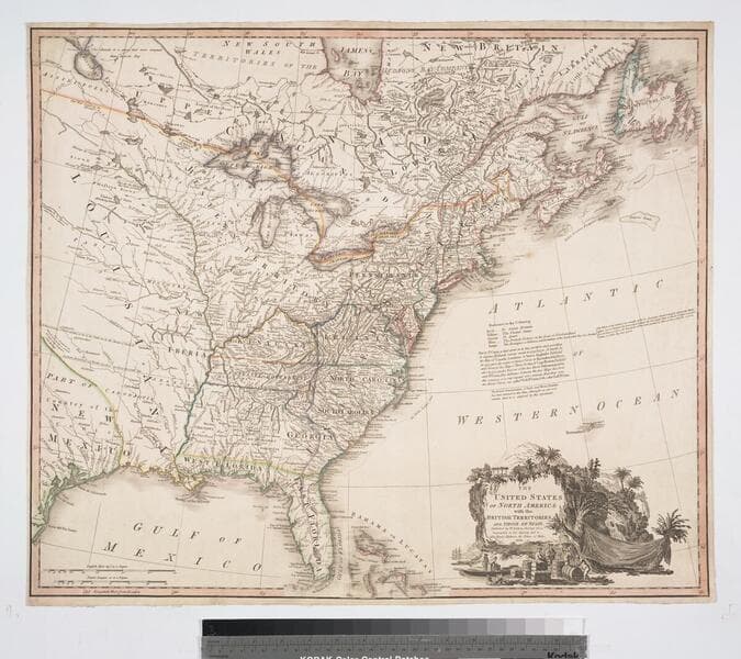
Kashnor notes, "Similar to Faden's map of "The British Colonies in North America," with the addition of colored contours indicative of the British, Spanish, French and American frontiers." See 105:148 for an earlier copy, 093:545 for a later copy. RLIN record adds appeared in information. Cartouche of Caribbean traders.. Prime meridian: London. Relief: pictorial. Projection: Pseudocylindrical. Printing Process: Copper engraving. Other Features: Cartouche. Verso Text: MS notes : 544.
093:544 M
Image not available
Visual Materials
Kashnor notes, "Similar to Faden's map of "The British Colonies in North America," with the addition of colored contours indicative of the British, Spanish, French and American frontiers." "Engraved by Wm. Faden." See 105:148 for an earlier copy, 093:544, 093:545 for later copies. RLIN record adds appeared in information. Cartouche of Caribbean traders.. Prime meridian: London. Relief: pictorial. Projection: Pseudocylindrical. Printing Process: Copper engraving. Other Features: Cartouche. Verso Text: MS notes : 654 Faden U.S.A. 1793.
105:654 M

Visual Materials
Kashnor notes, "Similar to Faden's map of "The British Colonies in North America," with the addition of colored contours indicative of the British, Spanish, French and American frontiers." See 093:544, 093:545 for later copies. Cartouche of Caribbean traders.. Prime meridian: London. Relief: pictorial. Projection: Pseudocylindrical. Watermark: Crowned fluer-di-lis VI. Printing Process: Copper engraving. Other Features: Cartouche. Verso Text: MS notes : 105 148.
105:148 M
Image not available
Visual Materials
Kashnor notes, "Ohio, Michigan, Illinois, Wisconsin and Minnesota of today were all comprised in the Western Territory, which is shown reaching to the Lake of the Woods, Chicago is located, and the State of Indiana is shown to be about 60 miles long and broad, situated below Ohio." Kashnor dates as ca. 1798. McCorkle dates as 1795. Cartouche: two maidens. . Prime meridian: London, Ferro. Relief: pictorial. Graphic Scale: Miles. Projection: Pseudocylindrical. Printing Process: Copper engraving. Other Features: Cartouche. References: McCorkle 791.1, 768.1(original). Verso Text: MS note: 513.
093:513 M
Image not available
Visual Materials
Kashnor notes, "Shows also part of Western Territory, and locates Chilicothe in Ohio; also the territories of the Wabash, Illinois and New Jersey Land Companies. It is a very good map of the Carolina countries." Prime meridian: GM. Relief: hachures. Graphic Scale: Miles. Projection: Pseudocylindrical. Printing Process: Engraving. Verso Text: MS note: 542.
093:542 M
Image not available
Visual Materials
Kashnor notes, "Shows the old boundaries, the western reaching to the Mississippi, and north to the Lake of the Woods, giving a good map of the Ohio, Illinois, Indiana, Michigan and Wisconsin countires in the early days." See also 105:651 for another copy. McCorkle furnishes the Anville/Jafferys connection. Cartouche: surmounted by 13 star American Flag, colored.. Prime meridian: London, Ferro. Relief: pictorial. Graphic Scale: Miles. Projection: Pseudocylindrical. Printing Process: Copper engraving. Other Features: Cartouche. References: McCorkle 794.1. Verso Text: MS note: 543.
093:543 M