Visual Materials
Survey of Lake Champlain, including Lake George, Crown Point and St. John. Surveyed by Order of His Excellency Major General Sr. Jeffery Amherst, Knight of the most Honble. Order of the Bath, Commander in Chief of His Majesty's Forces in North America, (now Lord Amherst) by William Brassier, Draughtsman. 1762

You might also be interested in

Survey of Lake Champlain, including Lake George, Crown Point and St. John. Surveyed by Order of His Excellency Major General Sr. Jeffery Amherst, Knight of the most Honble. Order of the Bath, Commander in Chief of His Majesty's Forces in North America, (now Lord Amherst) by William Brassier, Draughtsman, 1762
Visual Materials
Kashnor notes, "A rare map, issued specially for British Troops serving in the Revolutionary War." Sub map of Lake George Surveyed in 1756 by Capt. Jackson. Shows naval action at Valcour Island and Buttonmold Bay in Oct. 1776. Sub map of Lake George, Surveyed in 1756. by Capt. Jackson.. Relief: hachures. Graphic Scale: Miles, British. Projection: Plane. Watermark: Crowned fleur-di-lis V I. Printing Process: Copper engraving. Other Features: Sub-maps. Verso Text: 18 MS note: 112.
093:112 M
Image not available
Accurate map of the United States of America, with Part of the Surrounding Provinces agreeable to the Treaty of Peace of 1783. by Jno. Cary
Visual Materials
Kashnor notes, "One of the best of the English Treaty Maps. Shows the Illinois Country and the country runs north to the Lake of the Woods; also locates Carver's wintering place in 1755." Articles I-III of the treaty (lower right). Prime meridian: London. Relief: pictorial. Projection: Pseudocylindrical. Printing Process: Copper engraving. Verso Text: MS notes: 397 35.
093:397 M
Image not available
Nova Belgica et Anglia Nova
Visual Materials
Kashnor notes, "Locates Nieuw Netherland Territory, with Nieu Amsterdam on Manhattan, and Hellegat, also Nieu Plimouth and Briston in Nieu England." McCorkle gives 1635 date, suggest that Lake Iricoisiensis is confusion between Lake Champlain and Lake Winnepessaukee. Based on language and signature on verso, Van der Krogt dates this edition to between 1640 and 1643. Cartouche: Indians and Belgian shield; numerous figures and animals. Indian village. Prime meridian: Ferro. Relief: pictorial. Graphic Scale: Miles. Projection: Mercator. Printing Process: Copper engraving. References: McCorkle 635.1. Verso Text: Printed in French: La Nouvelle Belgique, & la Nouvelle Angleterre 3; C. MS note: 493.
093:493 M
Image not available
Map of Canada and the North Part of Louisiana with the adjacent Countrys. by Thos. Jefferys, Geographer to His Royal Highness the Prince of Wales
Visual Materials
Kashnor notes, "Shows the Illinois country and, further west, locates Ajaouez (Iowa). To the north-west is shown Lake Winnepeg with the St. Charles or Assiniboine River, and a little south is the elbow of the River of the West, showing the course much the same as that of the Columbia. A scarce and interesting western map." Numerous wormholes. MS note: 418 (on backing) 1760 on map. . Prime meridian: Ferro. Relief: pictorial. Projection: Mercator. Printing Process: Copper engraving. Verso Text: MS note: 418 (on backing).
093:418 M

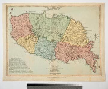
Grenada Divided into its Parishes, Surveyed By Order of His Excellency Governor Scott, and Engraved by Thomas Jefferys Geographer to the King
Visual Materials
Includes "Observations" on the island including "The Dotted Line along the Coast denotes the Fifty Paces belonging to the King." See 093:768 for a later copy. Prime meridian: London, Ferro. Relief: hachures. Graphic Scale: Feet, leagues. Projection: Cylindrical. Watermark: Crowned fleur-di-lis. Printing Process: Copper engraving. Verso Text: MS notes: 767 49.
093:767 M
Grenada Divided into its Parishes, Surveyed By Order of His Excellency Governor Scott, and Engraved by Thomas Jefferys Geographer to the King
Visual Materials
Includes "Observations" on the island including "The Dotted Line along the Coast denotes the Fifty Paces belonging to the King." See also 093:767M for an earlier copy. Prime meridian: London, Ferro. Relief: hachures. Graphic Scale: Feet, leagues. Projection: Cylindrical. Watermark: Crowned fleur-di-lis VI. Printing Process: Copper engraving. Verso Text: MS notes: 768.
093:768 M