Visual Materials
New Description of Carolina
You might also be interested in
Image not available
A New Chart of the Sea Coast of Newfoundland, new Scotland, new England, Virginia, Maryland, Pennsilvania, and part of Carolina
Visual Materials
Kashnor notes, "a very fine old chart." Kashnor dates as [1685]. Royal coat of arms.. Relief: no. Graphic Scale: Leagues. Projection: Cylindrical. Printing Process: Copper engraving. Other Features: Cartouche. Verso Text: MS note: 335 (on backing).
105:335 M
Image not available
New Map of South America, Shewing it's General Divisions, Chief Cities & Towns Rivers, Mountains &c. Dedicated to His Highness William Duke of Gloucester
Visual Materials
Kashnor attributes this map to Wells and dates as [1698]. RLIN record suggests 1700. Cartouche: Elaborate with Royal coat of arms, by a different artist than the map maker.. Prime meridian: Ferro. Relief: pictorial. Graphic Scale: Miles. Projection: Pseudocylindrical. Printing Process: Copper engraving. Other Features: Cartouche. Verso Text: MS notes: 40 615.
093:615 M

New Chart of the Bahama Islands And the Windward Passage by John Thornton Hydrographer At the Signe of England, Scotland, and Ireland, in the Minories London
Visual Materials
Kashnor notes, "Shows also Cuba, Jam aica and part of Hispanola bordering on the Windward Passage." Kashnor dates as ca. 1680. Cartouche: minimal. MS note: 741 (on backing) . Relief: pictorial. Graphic Scale: Leagues. Projection: Cylindrical. Printing Process: Copper engraving. Other Features: Cartouche. Verso Text: MS note: 741 (on backing) .
093:741 M
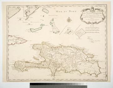
Carte de l'Isle de Saint Domingue Dresée en 1722 por le l'usage du Roy Sur les memoires de Mr. Frezier Ingenieur de. S. M. el autres assujetis aux Observations Astronomiques. Par G. Delisle premier Geographe du Roy, de l'Academie Rle. des Sciences. A Paris Chex l'Auteur sur le Quay de l'Horloge
Visual Materials
See 093:781M for a later copy. Cartouche: Framed w. coat of arms.. Prime meridian: Ferro. Relief: pictorial. Graphic Scale: Leagues. Projection: Cylindrical. Watermark: Chained Maltese cross device. Printing Process: Copper engraving. Other Features: Cartouche. Verso Text: MS note: 780.
093:780 M

Carte de l'Isle de Saint Domingue Dresée en 1722 por le l'usage du Roy Sur les memoires de Mr. Frezier Ingenieur de. S. M. el autres assujetis aux Observations Astronomiques
Visual Materials
See 093:780M for an earlier copy. Kashn or dates this as ca. 1730. Cartouche: Framed w. coat of arms. MS note: 49 (upper right). Prime meridian: Ferro. Relief: pictorial. Graphic Scale: Leagues. Projection: Cylindrical. Printing Process: Copper engraving. Other Features: Cartouche. Verso Text: MS note: 781.
093:781 M
Image not available
Newfound Land / described by Captaine John Mason an industrious Gent: who spent seven years in the Countrey [sic]
Visual Materials
Kashnor notes, "A lithographic reprint of this rare map." Kashnor dates this reprint as published ca. 1840. Original map was printed in William Vaughan's Cambrensium Caroleia (for 1625 edition see RB 51830; for 1630 edition see RB 51831). MS note: 260 (on backing) Royal Coat of Arms. Latin text block. Relief: no. Graphic Scale: Miles. Projection: Plane. Printing Process: Lithography. Verso Text: MS note: 260 (on backing).
093:260 S