Visual Materials
[Upper] Carte des Nouvelles Découvertes [Lower] Extrait d'une Carte Japonoise de l'Univers
You might also be interested in
Image not available
Carte des parties nord et ouest de l'Amérique
Visual Materials
Map shows date as 1772. Watermark indicates later printing date. Note regarding Baron de la Hontan's [apocryphal] explorations. Trimmed from upper right - Suppl. 1re. Carte. Atlas and publisher from McLaughlin and others. Trimmed to the neatline on three sides. MS note: 10 [on backing].. Relief: pictorial. Graphic Scale: No. Projection: Pseudocylindrical. Watermark: AM Herritte? 1778. Printing Process: Copper engraving.
105:010 S
Image not available
Carte Generale des Découvertes de l'Amiral de Fonte et autres Navigateurs Espagnols, Anglois et Russes pour le recherche du Passage a la Mer du Sud Par M. De l'Isle de l'Academie royale des Sciences &c
Visual Materials
Trimmed from upper right - Suppl. 7e. Carte. Atlas and publisher from McLaughlin and others. Submap titled Carte dresée sur la lettre de l'Amiral de Fonte par l"Ecrivain de la Californie.. Prime meridian: Paris. Relief: pictorial. Graphic Scale: No. Projection: Pseudocylindrical. Printing Process: Copper engraving. Other Features: Sub-maps.
105:012 S
Image not available
Carte Générale des Découvertes de l'Amiral de Fonte representiant la grande probabilitié d'un Passaga au Nord Ouest par Thomas Jefferys Geographe du Roi a Londres 1768
Visual Materials
Kashnor notes, "Includes the Polar regions from Siberia to Greenland, and southward as far as New Mexico, indicating not only the route of de Fonte, but also certain interesting Russian and Japanese discoveries up to 1741, including those on the coast of Alaska and British Columbia, though showing the fabrications of de Fonte. "Trimmed from upper right - Suppl. 8e. Carte. Atlas and publisher from McLaughlin and others. Prime meridian: Paris. Relief: pictorial. Graphic Scale: Marine leagues. Projection: Pseudocylindrical. Watermark: AM Herritte? 1778. Printing Process: Copper engraving.
105:013 S
Image not available
Nouvelle Représentation Des Côtes Nord et Est de L'Asie
Visual Materials
Kashnor notes, "Comprising three maps set within one another, representing respectively (i) the northern coast of Europe and Asia, with the coasts of Kamtschatka and China, Japan, &c.(ii) Nova Zembla, Siberia and Kamtschatka, (iii) the coasts immediately north of Japan, including "Mer de Lama" and "Mer d'Anadir." Suppl. 3e. Carte trimmed from upper border. Trimmed to neatline on three sides. Two sub maps of eastern Asia. MS note: 30. Prime meridian: Ferro. Relief: pictorial. Graphic Scale: No. Projection: Pseudocylindrical. Watermark: AM Herritte? 1778. Printing Process: Copper engraving. Other Features: Sub-maps.
105:030 S
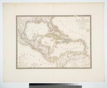
Carte des Iles Antilles ou Indes Occidentales, du Golfe du Mexique. et d'une partie des Pays Adjacents
Visual Materials
"par A. Brué Geographe du Roi." "Gravee sous le direction de l'Auteur." "Atlas Universel." "Pl 55" Prime meridian: Paris. Relief: hachures. Graphic Scale: Leagues, miles. Projection: Conic. Printing Process: Copper engraving. Verso Text: MS note: 946.
105:946 M
Image not available
Carte de la Californie et des Pays Nord-Ouest separés de l'Asie par le Détroit d'Anian, extraite de duex Cartes publiées au commencement du 17e Siécle
Visual Materials
Kashnor notes, "Contains two maps of the same country, on different scales, one inset on the other." Two maps on one sheet.. Prime meridian: Paris. Relief: pictorial. Graphic Scale: No. Projection: Pseudocylindrical. Printing Process: Copper engraving. Other Features: Sub-maps. References: Wagner 542; Wheat 159; Phillips 1195..
105:219 S