Visual Materials
An Accurate Map of North America Drawn from the Sieur Robert, with improvements
You might also be interested in
Image not available
Accurate map of South America; Drawn from the Sieur Robert, Geog. to the French King with Improvements
Visual Materials
Kashnor daters as ca. 1760. MS note: 607 (on backing) Cartouche: minimal flowered.. Prime meridian: London. Relief: pictorial. Projection: Azimuthal. Printing Process: Copper engraving. Other Features: Cartouche. Verso Text: MS note: 607 (on backing).
093:607 S

New and Accurate Map of North Carolina in North America
Visual Materials
Kashnor notes,"A scarce map issued during the early days of the American Revolution." Kashnor dates as [1776]. MS note: 376 (on map and backing). Transfer text upper left corner.. Prime meridian: London. Relief: pictorial. Graphic Scale: Miles. Projection: Plane. Watermark: Two seals.. Printing Process: Copper engraving. Other Features: Cartouche. Verso Text: MS note: 11. 376(on backing)..
093:376 S

A new and accurate map of the province of Georgia in North America
Visual Materials
Kashnor notes, "Shows the old trading paths and the Hunting Grounds of the Cherokees." Kashnor dates c.1776. RLIN record notes date as [1779?] and place of publication as [London?] and as appearing in The Universal Magazine of 1779. See 093:391 and 105:103 for additional copies. MS note: 94 (on backing). Prime meridian: [Ferro]. Relief: pictorial. Projection: Cylindrical. Watermark: Crowned circular seal. Printing Process: Copper engraving. Other Features: Cartouche. Verso Text: MS note: 32 94(on backing).
093:094 S
Image not available
A new and accurate map of the province of Georgia in North America
Visual Materials
Kashnor notes, "Shows the old trading paths and the Hunting Grounds of the Cherokees." Kashnor dates c.1776. RLIN record notes date as [1779?] and place of publication as [London?] and as appearing in The Universal Magazine of 1779. See 093:391 and 105:103 for additional copies. MS note: 391 (on backing). Prime meridian: [Ferro]. Relief: pictorial. Projection: Cylindrical. Watermark: Crowned circular seal. Printing Process: Copper engraving. Other Features: Cartouche. Verso Text: MS note: 391 (on backing).
093:391 M
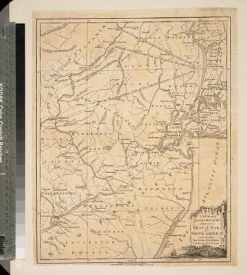
New and Accurate Map of the Present Seat of War in North America, Comprehending New Jersey, Philadelphia, Pensylvania (sic), New-York &c
Visual Materials
Kashnor dates as c.1770. Probably later because of reference to Revolutionary War. Some notes regarding boundary dispute between New York and New Jersey. Small vined cartouche with sailing ship. MS note: 101 (on backing). Prime meridian: London. Relief: pictorial. Graphic Scale: Miles, statute. Projection: Cylindrical. Watermark: Crowned seal. Printing Process: Copper engraving. Other Features: Cartouche. Verso Text: MS note: 410 (map) 101 (on backing).
093:101 S

Map of Martinico, from the latest and best Authorities
Visual Materials
Kashnor dates as ca. 1759. Submap: Map of that part of Guadaloupe, where the English made their Descent, Jany. 23 1759. MS note: 818 (on backing). Prime meridian: London. Relief: hachures. Graphic Scale: Miles. Projection: Cylindrical. Printing Process: Copper engraving. Other Features: Sub-maps. Verso Text: MS note: 818 (on backing).
093:818 S