Visual Materials
New Map of the Island of Barbadoes wherein every Parish, Plantation, Watermill, Windmill & Cattlemill is described with the name of the Present Possesor, and all things els remarkable according to a Late Exact Survey therof

You might also be interested in

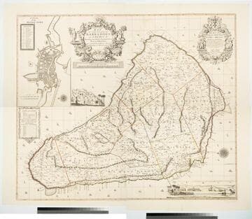
New Map of the Island of Barbadoes wherein every Parish, Plantation, Watermill, Windmill & Cattlemill is described with the name of the Present Possesor, and all things els remarkable according to a Late Exact Survey therof
Visual Materials
Kashnor notes, " very rare map. A printed description of the Island is inset in the bottom right hand corner." Descriptive text gives history and information on products, shipping and government. Kashnor dates as circa 1690. This map is the same map as 105:175, with Philip Lea's name removed and the blank cartouche now including names of other map sellers. No mention of Lea's Jamaica map. Figures around descriptive information. Blank cartouche. Submaps of towns, not detailed. Puti on scale, whales with curly tails.. Relief: pictorial. Graphic Scale: Miles. Projection: Plane. Printing Process: Copper engraving. Other Features: CartoucheSub-mapsFigures . Verso Text: MS notes: 176.
105:176 M

A new Mapp of Jamaica According to the last Survey
Visual Materials
Kashnor notes, "With a very curious cut north of the Porus Mountains, apparently representing two men fighting a duel with muskets. The original issue of Moxom's exceedingly rare map." Cartouche: Indians, coat of arms. Figures: Native holding scale, farm animals, pineapples, dueling figures. Dedication subcartouche.. Relief: pictorial. Graphic Scale: Miles. Projection: Cylindrical. Printing Process: Copper engraving. Other Features: CartoucheFigures . Verso Text: MS note: 459.
105:459 M
New and Exact Map of the Island of Barbadoes in America, According to an Actual and Accurate Survey made by William Mayo
Visual Materials
Kashnor notes, "Dedicated to James Bridges, Duke of Chandos. With inset plan of Bridgetown, prospect of Codrington College, and engraving representing the making of the survey; also statistics of population." See also 093:745M, another copy as engraved by John Senex 1722. Two elaborate cartouches. Submap - A Plan of Bridgetown. A view of Codrington College. View of surveyor with plane table, and native assistants with measuring wheel, surveying pole and chain. . Prime meridian: London. Relief: pictorial. Graphic Scale: Miles. Projection: Plane. Watermark: JW Whatman 1794. Printing Process: Copper engraving. Other Features: CartoucheSub-mapsVignettes. Verso Text: Ms notes: 174 4 sheets 23, 24, 25, 26..
105:174 M
Image not available
North America and the West Indies: a New Map, wherein the British Empire and its limits, according to the difinitive(sic) Treaty of Peace in 1763, are accurately described, and the Dominions possessed by the Spaniards, the French and other European States; the whole compiled from the New Surveys and Authentic Memoirs that have hitherto appeared
Visual Materials
Kashnor notes, "Shows a good map of the Illinois and Ohio country. locating Chicago. The southern boundary of the Hudson's Bay Company territories is along latitude 49, running beyond the Lake of the Woods. In the map are also located the various H. B. Co. forts and factories." Kashnor dates as ca. 1763. Submaps and treaty articles. See 105:669 for another copy. RLIN record suggests 1764 date. Cartouche with Natives. Submaps: Particular Map of Baffin and Hudson's Bay; Map of the Country between Montreal, Albany and Oswego. . Prime meridian: London, Ferro. Relief: pictorial. Graphic Scale: Miles, Leagues. Projection: Pseudocylindrical. Printing Process: Copper engraving. Other Features: CartoucheSub-mapsFigures . Verso Text: MS notes: 532 Map c.1783.
093:532 M

Dominia Anglorum in preacipius Insulis Americae, ut sunt Insula St. Christophi, Antegoa, Jamaica, Barbadoe, necnon Insulae Bermudes vel Sommers dictae
Visual Materials
Kashnor notes, "a scarce map. five maps on one sheet." Map title is both Latin and German, place names on maps in English. Kashnor dates as c. 1750, publication in Nuremberg. See 105:182M for another state of this map, possibly earlier. RLIN record dates as 1759. Five submaps: St. Kitts, Antigua, Bermuda, Barbados, Jamaica. Relief: pictorial. Graphic Scale: Milliaria. Projection: Plane. Watermark: Shield or device. Printing Process: Copper engraving. Verso Text: MS note: 950.
105:950 M
Image not available
Asia Corrected, According to the latest Discoveryes & Observations Communicated to the Royal Society at London and the Royal Academy at Paris
Visual Materials
Kashnor notes, "Includes Manila and the Philippine Islands." See 105:256 for another map with Willdey's wares noted. Numerous figures and views adorn this map. Cartouche: Surrounded by figures in "The different Habits of the People of several Nations in these parts." Vignette: "A Lady of Japan taking the Airs." Advertisement for Willdey's goods. Pictorial representation of Willdey's goods. (upper left). "By Eman. Bowen, 1714." Prime meridian: London. Relief: pictorial. Graphic Scale: Leagues, Miles. Projection: Azimuthal. Printing Process: Copper engraving. Other Features: CartoucheVignettesFigures Art Work. Verso Text: MS notes: 732 Asia.
105:732 M