Rare Books
Nova planta da cidade do Rio de Janeiro

You might also be interested in

Nova carta chorographica do Imperio do Brazil : reduzida pelo bacharel Pedro Torquato Xr. de Brito, Tenente Coronel Gro. do Corpo d'Engenheiros e Socio effectivo do Instituto Polytechnico Brasileiro, da que foi confeccionada pelo Coronel Conrado Jacob de Niemeyer, e outros officiaes engenheiros em 1856
Rare Books
Kirkpatrick Catalogue entry: "2475 Niemeyer, C. J. de Nova carta chorographica do Imperio do Brazil ...1856. [Rio de Janeiro], Gravada na Litha. do Archo. Militar por Alvaro e Pereira, 1867. 1 sheet. [see p.]."MS label on verso reads "Coronel Niemeyer's Map of Brazil." Probably obtained while Burton was in South America between 1865 and 1868. Prime meridian: Rio de Janeiro. Relief: hachures. Graphic Scale: Leagues, kilometers. Projection: Cylindrical. Printing Process: Lithography. Verso Text: Label: Coronel Niemeyer's Map of Brazil. Stamp: Kensington Public Libraries.
623649

Carta da Provincia de Minas Geraes : coordeuado por ordem do Exm. Sr. Conselheiro José Bento da Cunha Figueiredo Presidente da Provincia, segundo os dados officiaes existentes e muitas proprias observações / por Henrique Gerber Engenheiro de Mesma Provincia
Rare Books
Kirkpatrick Catalogue entry: "2464 d Gerber, H. Carta da Provincia de Minas Geraes; coordeuado por ordem do. Exm. Sr. Conselheiro José Bento da Cunha Figueiredo, Presidente do Provincia ... [Rio de Janerio], 1862. 1 sheet. [see p.]."MS notes southwest of Diamantina and near Bagagem, now marked on maps as Iraí de Minas. Penciled in grid covers much of the map. Meridian given is actually Pao de Assucar, which refers to Sugarloaf Mountain in Rio de Janeiro. A drastically reduced and simplified version of this map appeared in Henrique Gerber's Noções geographicas e administrativas da Provincia de Minas Geraes, 1863 (Burton collection number 1821). Probably purchased while Burton was in South America between 1865 and 1868. Prime meridian: Rio de Janeiro. Relief: hachures. Graphic Scale: Leagues, kilometers. Projection: Cylindrical. Printing Process: Lithography. Verso Text: MS note: Brazil Stapms: Kensington Public Libraries.
623638
Image not available
Pequeno panorama ou Descripção dos principaes edificios da cidade do Rio de Janeiro
Rare Books
635304
Image not available
Milton B. Stevens. To Abbey Stevens. Rio de Janeiro, Brazil
Manuscripts
The collection contains 62 letters by 26 different authors including Milton B. Stevens, C. K. Dixon and Byron Whitcomb. The letters mention various mining camps throughout Northern California, such as Fosters Bar, Galena Hill, Murderers Bar, Pilot Hill, Salmon Falls, Weber Creek, and the Klamath River Valley Mines, as well as several California cities including Benicia, Sacramento, San Francisco, San Jose, and Stockton. The letters illustrate several aspects of the Gold Rush experience: the journey to California through Panama and Rio de Janeiro; life in California and the gold camps; women in California; gold discoveries or the lack thereof; the techniques and equipment used in mining; loneliness and longing for home. The letters from Milton B. Stevens' mother, from Shushan, tell of the experience of the miners' families back at home in the East. Eighteen of the letters have handwritten or typed transcripts.
HM 59473
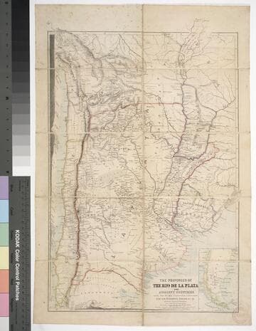
The provinces of the Rio de la Plata and adjacent countries : chiefly from the map constructed / by J. Arrowsmith for Sir Woodbine Parish, K.C.H., drawn by Augustus Petermann
Rare Books
Kirkpatrick Catalogue entry: "2458 d Arrowsmith, J. The provinces of the Rio de la Plata and adjacent countries, chiefly from the map constructed ... for Sir Woodbine Parish ... drawn by Augustus Petermann. [London], A. Petermann, [1850?]. 1 sheet. [see p.]."Includes section views: "Section from Raya Pass to Buenos Ayres through the Peru Bolivian Tablelands, and the Travesia and the Pampas of La Plata" and "Section from Valpraiso to Buenos Ayres." The map by Sir Woodbine Parish, on which this is based, was published in 1852. Martin de Moussy published his Description géographique et statique de la Confédération Argentina after this map, in 1860. (Técnica, política y "deseo territorial" en la cartografía oficial de la Argentina (1852-1941), Carla Lois, Scripta Nova, volume 10, number 218 (52), August 1 2006.) Probably obtained while Burton was in South America between 1865 and 1868. Submap: Section from Raya Pass to Buenos Ayres, through the Peru Bolivian Tablelands and the Traversia and the Pampas of La Plata; Patagonia and Tierra del Fuego. Stamp: Kensington Public Library. MS notes in Paraguay and Brazil.. Prime meridian: GM. Relief: hachures. Graphic Scale: Miles, leagues. Projection: Polyconic. Printing Process: Lithography. Other Features: Sub-maps. Verso Text: Stamp: Kensington Public Library (3).
623632
![Track of the H.M.S. Asia from Lisbon to Rio Janeiro 1st Decber. 1847 to 13th Febry. 1848 [cartographic material] / W. Denison](/_next/image?url=https%3A%2F%2Frail.huntington.org%2FIIIF3%2FImage%2F22APN4MO8BXO%2Ffull%2F%5E360%2C%2F0%2Fdefault.jpg&w=750&q=75)
Track of the H.M.S. Asia from Lisbon to Rio Janeiro 1st Decber. 1847 to 13th Febry. 1848 [cartographic material] / W. Denison
Manuscripts
One of four manuscript maps showing the voyages of the H.M.S. Asia, 1848-1851. This map shows the outward bound leg from Lisbon to Rio de Janeiro of the larger roundtrip voyage charted in mssHM 15468 map 1, beginning in January 1848 (despite the 1847 date given in the map's title). Designated "No 4" at top.
mssHM 15468 map 3