Rare Books
Map of South Western Arabia

You might also be interested in

Map of N. West Arabia / Mr. G.A. Wallin
Rare Books
Kirkpatrick Catalogue entry: "2499 Wallin, G. A. Map of N. west Arabia. [London, 1850]. 1 sheet (holograph). From the Journal of the Royal Geographical Society, Vol. 20. [see p.].Map of the route Wallin took in 1845, also includes numerous notes of locations and bearings. Also shows regions where Burton believed gold and silver might be found, noted in his hand. Another version of this map was published in the Journal of the Royal Geographic Society, volume 20, 1860, accompanying Wallin's article. This map is also heavily annotated. Many MS notes. Stamp: Kensington Public Libraries.. Prime meridian: GM. Relief: hachures. Projection: Polyconic. Printing Process: holographic.
623673

Arabia, the Red Sea, and the Valley of the Nile, including Egypt, Nubia, and Abyssinia / by W. Hughes, F.R.G.S
Rare Books
Kirkpatrick Catalogue entry: "2490 d l Hughes, W. Arabia, the Red Sea, and the valley of the Nile, including Egypt, Nubia, and Abyssinia. London, Liverpool, George Philip, [1867]. 1 sheet. [see p.]."Alternate title from cover. MS notes and lines drawn in blue and red pencil. Another MS note seems to indicate the path that Sir Richard took on his famous journey to Mecca Submap: North-eastern Abyssinia. MS notes: regarding reprinting part of this map.. Prime meridian: GM. Relief: hachures. Graphic Scale: Miles, kilometers. Projection: Polyconic. Printing Process: Lithography. Other Features: Sub-maps. Verso Text: MS notes: p maps Hughes Stamps: Kensignton Public Libraries..
623664

To His Highness Omar Pasha, G.C.B. &c., &c., &c. Generalissimo of the Ottoman Armies and Governor General of Turkish Arabia, this plan of the supposed ruins of Babylon / by William Beaumont Selby, Commander Indian Navy & Surveyor in Messopotamia assisted by Lieut. W. Collingwood, I.N is with his Highnesses permission and as a small tribute to his Highnesses interest and zeal in the cause of antiquarian research respectfully dedicated
Rare Books
Kirkpatrick Catalogue entry: "2397 Selby, W. B. This plan of the supposed ruins of Babylon ... assisted by ... W. Collingwood ... [London?], J. & C. Walker, engraver, [1874?]. 1 sheet [see cabinet]. At head of title: His Highness Omar Pasha ... Generalissimo of the Ottoman Armies, and Governor General of Turkish Arabia."According to A catalogue of manuscript and printed reports, field books, memoirs, maps, etc. of the Indian Survey deposited in the map room of the India Office (1878), this dates to 1859 (page 494). Selby published his Memoirs on the ruins of Babylon, in 1859. Prime meridian: GM. Relief: hachures. Projection: Plane. Printing Process: Lithography. Verso Text: MS notes: Burton (map cabinet) Selby 2497.
623671
Image not available
Map of the continental railways in connection with the London, Brighton & South Coast and Western of France Railways
Rare Books
Kirkpatrick Catalogue entry: "2534 Waterlow & Sons. Ltd., publisher. Map of the continental railways in connection with the London, Brighton & south coast and western of France railways. London. [18--]. 1 sheet. [see p.]."Alternate title printed sideways in right margin. Submap on verso. “The London, Brighton & South Coast Rwy., amalgamated from the London & Croydon and London & Brighton lines in 1846, dominated the area immediately south of London. Victoria Station was also its terminus, which it opened on October 1, 1860.” From World railways of the nineteenth century: a pictorial history in Victorian engravings, by Jim Harter, 2005, page 20.The dates suggested are the year Victoria Station (which appears on the map on the verso), and the year of Burton's death. MS notes: 2534 p. maps Europe Waterlow.. Prime meridian: GM. Relief: no. Projection: Cylindrical. Printing Process: Lithography. Other Features: Sub-maps. Verso Text: Submap: London, Brighton and South Coast Railway. Metropolitan & Suburban Lines & Connections..
623707
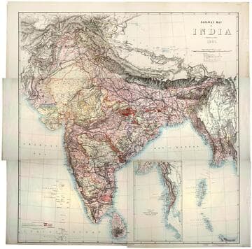
Railway map of India
Rare Books
Kirkpatrick Catalogue entry: "2493 [India. Survey of India Dept.] Railway map of India. [Calcutta, 1885]. 6 sheets. [see cabinet]." Submap: Continuation of the Province of Nritish Rurmah (Tenasserim Division) MS notes: Burton (map cabinet) India Railway . Prime meridian: GM. Relief: hachures. Graphic Scale: Miles. Projection: Polyconic. Printing Process: Lithography. Other Features: Sub-maps.
623667

Stanford's library map of South America / constructed by A. Keith Johnston, F.R.S.E. F.R.G.S. &c
Rare Books
Kirkpatrick Catalogue entry: "2466 d h Johnston, A. K. Stanford's library map of South America. London, Edward Stanford, [1864]. 3 sheets. [see p.]."a 4th sheet is missing.Newspaper review clipping, from the Sunday Review, dated July 23, 1864, attached to southwest portion of map. Probably obtained while Burton was in South America between 1865 and 1868. Prime meridian: GM. Relief: hachures. Graphic Scale: Miles, kilometers, leagues. Projection: Polyconic. Printing Process: Lithography.
623640