Visual Materials
Map of the City of Ontario, San Bernardino Co. Cal
You might also be interested in
Image not available
Part of Cucamonga Fruit Land Co's. property in sections 4, 5, 8 and 9 as per survey made in April 1897 / by W.B. Nicholson
Visual Materials
Old shelf number: eph J4-12(3). Publisher transcription from verso. This appears to be the section of Alta Loma/Cucamonga north of Foothill Blvd. (San Bernardino County Road on this map) near the intersection with Vineyard Avenue. Prime meridian: GM. Relief: hachures. Graphic Scale: Feet. Projection: Plane. Printing Process: Blueprint. Verso Text: MS notes: O.P.C. Cucamonga Eph J4-12(3). Hand drawn map of land near Yuba and Sutter Counties Stamp: Olin G. McWain Blue Printing. Byrne Bldg. Los Angeles, Cal.
ephMPCALIFT0083
Image not available
Map of northern portion of the Rancho Ex Mission de San Fernando, Los Angeles Co., Cal
Visual Materials
Old shelf number: eph J5-18(1). This map divides the interests of Porter Land & Water Co., George K. Porter, and B.F. Porter by hand colored boundaries. Shows Catalina Pico and Rinaldi ranch holdings, the towns of "Fernando" and "Chatsworth-Park." MS notes on property use and disposition. Olin G. McWain, whose stamp is on the verso, did not start working as a blueprint and map printer until 1898, based on Los Angeles directories of the time; the company continued until at least 1920 in the Byrne Building. Prime meridian: GM. Relief: no. Graphic Scale: Miles. Projection: Cylindrical. Printing Process: Blue print copy. Verso Text: MS notes: Eph J5-18(1). Blueprint of Rancho Ex Mission de San Fernando, Los Angeles, Calif. Stamp: Olin G. McWain Blue Printing and Map Mounting, Byrne Bldg., Los Angeles, Cal.
ephMPCALIFT0110

Map of Elysian Park Tract, Being a Re-subdivision of the Solano Tract No. 2
Manuscripts
Park Row and Elysian Park to Effie St., Yuba St. to Yolo Dr.; certification notes and approval; one lot is hand colored . Verso: stamp: Olin G. McWain Blue Printing, Byrne Bldg. Los Angeles, Cal.; in pencil: "insurance". [see also Maps 743, 748]. Alt title supplied by cataloger.
mssSolano SR_Map_0749.01
Image not available
Map of Brownlands Home Acres ; Riverside County California
Visual Materials
Old shelf number: eph J4-11(3). A tract in what was Eden Hot Springs now part of Moreno Valley. Prime meridian: GM. Relief: no. Graphic Scale: Feet. Projection: Plane. Printing Process: Blue line print. Verso Text: Stamp for Olin G. McWain Blue printing map mounting Los Angeles. MS building plan for home. MS Eph J4-11(3).
ephMPCALIFT0073
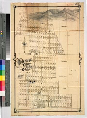
Map of the Ontario Colony lands : showing the location boundary, plan of subdivision & numbering of the blocks
Rare Books
Centered on Euclid Avenue north of train tracks. MS note: Map accompanying C. Frankish order of May 10, 1888. Stamp of Cement Pipe Co. May 11, 1888. "Address Chaffey Bros. Ontario San Bernardino Co. Cal." MS note: 255191. Prime meridian: GM. Relief: pictorial. Graphic Scale: Chains. Projection: Cylindrical. Printing Process: Lithography. Verso Text: MS note: 255191.
255191

Solano Tract No. 2
Manuscripts
Copy of previous maps with some lots filled in with pink coloring; pencil calculations. Verso: stamp: Olin G. McWain Blue Printing, Byrne Bldg. Los Angeles, Cal.. [see also Map 743]. Alt title supplied by cataloger.
mssSolano SR_Map_0748.05