Visual Materials
Map of Ivanhoe, Los Angeles County, Cal
You might also be interested in
Image not available
Preliminary map of portion of Bel-Air Estates on westerly slope of Stone Canyon in the City of Los Angeles, Calif
Visual Materials
Old shelf number: eph J5-10(1). Prime meridian: GM. Relief: no. Graphic Scale: Feet. Projection: Plane. Printing Process: Blue line print. Verso Text: MS note: Eph J5-10(1).
ephMPCALIFT0133
Image not available
Map of Vernon Park Tract, Los Angeles County, California / surveyed July, 1887, by V.J. Rowan
Visual Materials
Old shelf number: eph J5-7(1). Part of the City of Los Angeles just west of present day Vernon. Prime meridian: GM. Relief: no. Graphic Scale: Feet. Projection: Plane. Printing Process: Lithography. Verso Text: MS note: Eph J5-7(1).
ephMPCALIFT0129
Image not available
Map of Huntington, Cabell County, West Virginia
Visual Materials
Old shelf mark Eph J5-26(9). MS notes: Company Property 500 Acres Ohio. Prime meridian: GM. Relief: hachures. Graphic Scale: Feet. Projection: Plane. Printing Process: Lithography.
ephMPWVAT0002
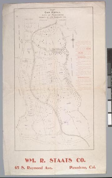
Map of Oak Knoll in the City of Pasadena and the County of Los Angeles, Cal. / surveyed in 1906 by J. O. Marsh C.E
Visual Materials
Old shelf number: eph J5-17(3). An exclusive area even then, the Huntington-Sheraton-Four Seasons- Hotel is shown with it's original name, "The Wentworth." Building restrictions are listed. Prime meridian: GM. Relief: no. Graphic Scale: Feet. Projection: Plane. Printing Process: Lithography. Verso Text: MS note: Eph J5-17(3).
ephMPCALIFT0146
Image not available
Map of a portion of Tide Land Location No. 154 City of Los Angeles, Calif. Wilmington District / surveyed in March 1926 by V.J. Rowan - J.E. Roberts (Surveyors)
Visual Materials
Old shelf number: eph J5-11(3). Prime meridian: GM. Relief: no. Graphic Scale: Feet. Projection: Plane. Printing Process: Blueprint. Verso Text: MS note: Eph J5-11(3).
ephMPCALIFT0136
Image not available
Huntington Drive Tract No. 2 Los Angeles County, California E.T. Wright, Surveyor. 40 minutes from Los Angeles, Wm. R. Staats Co., Agent
Visual Materials
Old shelf number: eph J5-17(2). Huntington Drive is now Sierra Madre Blvd. Holladay is now Lombardy Road. MS notes on property. Prime meridian: Gm. Relief: no. Graphic Scale: Feet. Projection: Plane. Printing Process: Lithography. Verso Text: MS note: Eph J5-17(2).
ephMPCALIFT0145