Opening Hours
Daily: 10 A.M.–5 P.M.
Closed on Tuesdays
1151 Oxford Road
San Marino, CA 91108
Visual Materials
Daily: 10 A.M.–5 P.M.
Closed on Tuesdays
1151 Oxford Road
San Marino, CA 91108

Image not available
Visual Materials
Kashnor notes, "Locates the borders of La Plata, Uruguay, and Paraguay." This is a copy of Visscher's map, see 093:632. See also 093:634, 093:635 for other versions. RLIN record suggests print date is actually 1718. Cartouche: Figures.. Prime meridian: Ferro. Relief: pictorial. Graphic Scale: Leagues. Projection: Pseudocylindrical. Watermark: Chained maltese cross lettering. Printing Process: Copper engraving. Other Features: Cartouche. Verso Text: MS note: 633 3J.
093:633 M
Image not available
Visual Materials
This is Buache's copy of Visscher's map, see 093:632. See also 093:633, 093:634 for other versions. Cartouche: Figures.. Prime meridian: Ferro. Relief: pictorial. Graphic Scale: Leagues. Projection: Pseudocylindrical. Watermark: Circled device lettering. Printing Process: Copper engraving. Other Features: Cartouche. Verso Text: MS note: 633 3J.
093:635 M
Image not available
Visual Materials
This is a copy of Visscher's map, see 093:632. See also 093:633, 093:635 for other versions. Alt. title from head of page. Kashnor dates as ca. 1720. See also 105:924 for another copy. Cartouche: Figures. Prime meridian: Ferro. Relief: pictorial. Graphic Scale: Leagues. Projection: Pseudocylindrical. Printing Process: Copper engraving. Verso Text: MS note: 633 3J.
093:634 M
Image not available
Visual Materials
This is a copy of Visscher's map, see 093:632. See also 093:633, 093:635 for other versions. Kashnor dates as ca. 1720. RLIN record suggests 1718. Cartouche: Figures. Prime meridian: Ferro. Relief: pictorial. Graphic Scale: Leagues. Projection: Pseudocylindrical. Watermark: M W. Printing Process: Copper engraving. Verso Text: MS note: 924.
105:924 M
Visual Materials
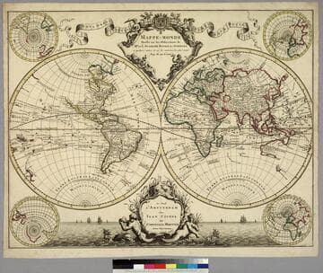
Kashnor notes, "One of the earliest maps to show California with a continuous coastline, and showing the tracks of St. Antoine [1710], Mandana and Quir, Tasman, and other discoverers." This is a copy of L'Isle's 1700 map (093:180) with added border art, redone cartouche, the tip of South America corrected, the Solomon Islands moved. Kashnor dates as [1720] as does Shirley. This map shows corrections from 105:245 in Siberia, but the east coast of Korea is shown in the manner of the 1700 map. Name corrections in Africa on 105:245 do not appear. Compare with 105:244M dated 1720 with a less westerly trending California peninsula and Frisland no longer shown below Greenland. Route of the Mississippi and shape of Hudson's Bay follow the 1700 map, indicating this map may have been printed before the dated 105:244M copy and before the undated 105:245. Cartouche - figures representing four continents. Four submaps, arctic and antarctic polar views, one centered on Paris, another on Paris antipode. Merman and Mermaid with sailing vessels lower margin.. Prime meridian: Ferro. Relief: pictorial. Projection: Dual Hemisphere. Printing Process: Copper engraving. Other Features: CartoucheSub-maps. References: Shirley 603 (mentioned). Verso Text: MS notes: 181.
093:181 M