Visual Materials
California
You might also be interested in
Image not available
Union Pacific and Southern Pacific Systems 1908
Rare Books
Shows lines in operation and under construction. Also shows San Pedro-Los Angeles-Salt Lake system, other railroads, lines extending into northern Mexico, and connecting steamship routes. Submaps: Los Angeles and Vicinity; San Francisco and Vicinity; Portland and Vicinity. Prime meridian: GM. Relief: no. Graphic Scale: Miles, kilometers. Projection: Cylindrical. Printing Process: Lithography.
492473
Image not available
Union Pacific and Southern Pacific systems
Rare Books
Covers the United States west of the Mississippi River and the northern states of Mexico. Also shows lines under construction. Also shows steamship lines. Shows Indian reservations. Includes index. Submaps: Los Angeles and Vicinity; San Francisco and Vicinity; Portland and Vicinity. Prime meridian: GM. Relief: no. Graphic Scale: Miles, kilometers. Projection: Cylindrical. Printing Process: Lithography.
492472
Image not available
Map of California, Nevada and Southern Oregon
Rare Books
"71011 M." Submaps: Los Angeles & vicinity; San Francisco & vicinity. Prime meridian: GM, Washington. Relief: hachures. Graphic Scale: Miles. Projection: Cylindrical. Printing Process: Lithography.
263315
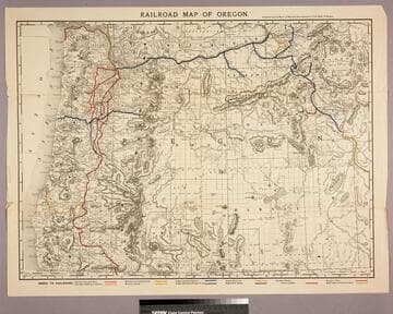
Railroad map of Oregon
Visual Materials
No old shelf mark. Hand colored rail lines. Prime meridian: Gm. Relief: hachures. Graphic Scale: Miles, kilometers. Projection: Cylindrical. Printing Process: Lithography. Verso Text: MS note: O2/2.
ephMPOR0007
Image not available
Road map of California Nevada
Visual Materials
No old shelf mark. Verso Los Angeles map does not show Arroyo Parkway, hence this map issued before 1941. Verso shows Arizona and city maps. Prime meridian: GM. Relief: hachures. Graphic Scale: Miles. Projection: Polyconic. Printing Process: Lithography. Verso Text: Submaps: Arizona; San Francisco and East Bay Cities; Los Angeles; Phoenix; San Diego; Western United States.
ephMPCALIFR0007
Image not available
Texaco touring map of Southern California metropolitan area
Visual Materials
No old shelf mark. This map shows the Arroyo Seco Parkway opened in 1941 but no other freeways. Prime meridian: GM. Relief: no. Graphic Scale: Miles. Projection: Cylindrical. Printing Process: Lithography. Verso Text: Three submaps: Southwestern Playgrounds; Kings Canyon and Sequoia; Yosemite.
ephMPCALIFR0001