Visual Materials
Map showing extensive mine workings and camp buildings : Adams Camp on Midget No. 1 Placer ; Palomas Mining District Los Angeles County Calif
You might also be interested in
Image not available
U.S. Topographic map showing location of Adams placer mining claims : Palomas Mining District, Los Angeles County California
Visual Materials
Old shelf number Eph J2d. Photocopy. A modified USGS topo map showing Charlie Canyon just to the west of Placerita Canyon and north of Castaic. Prime meridian: GM. Relief: contour lines. Graphic Scale: Feet. Projection: Polyconic. Printing Process: Photocopy. Verso Text: MS note: Eph J2d.
ephMPCALIF0148
Image not available
Map of Adam's Placer Mining Claims Charlie Canyon Los Angeles County, Calif
Visual Materials
Old shelf number Eph J2d. A long detailed map of mining claims in Charlie Canyon north of Castaic. Prime meridian: GM. Relief: no. Graphic Scale: feet. Projection: Plane. Verso Text: MS note: Eph J2d.
ephMPCALIF0149

Map of Iron Mountain and adjacent mining claims Los Angeles County Calif
Visual Materials
Old shelf number Eph J2d. Near Charlton Flats off Angeles Crest Highway. For a blueprint, see RB ephMPCALIF0146. Prime meridian: GM. Relief: no. Graphic Scale: Feet. Projection: Plane. Verso Text: MS note: Eph J2d.
ephMPCALIF0145

Map of Iron Mountain and adjacent mining Claims Los Angeles County Calif
Visual Materials
Old shelf number Eph J2d. Near Charlton Flats off Angeles Crest Highway. This is a blueprint of ephMPCALIF0145. Prime meridian: GM. Relief: no. Graphic Scale: Feet. Projection: Plane. Printing Process: Blueprint copy. Verso Text: MS note: Eph J2d.
ephMPCALIF0145a
Image not available
Topographical map of Charlie Canon [sic] ; Los Angeles County Calif / Frank J. Cramer
Visual Materials
Old shelf number Eph J2d. Photocopy. The key map which John Duling would use to construct his later maps of this region, reverse printed. Submap: Key map of lode claims and placer claims. Prime meridian: GM. Relief: no. Graphic Scale: Feet. Projection: Plane. Printing Process: photocopy. Verso Text: MS notes : Eph J2d Adams Placers 3'-9" long.
ephMPCALIF0151
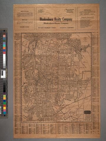
Map of Pasadena
Visual Materials
Map is untitled. Old shelf number: Eph J2d. Thurston kept updating his Pasadena map and the verso Road Map of Southern California. The latest statistics quoted are from 1921, hence the guess of 1922 for this maps date. MS note: Eph J2d. Prime meridian: GM. Relief: hachures. Graphic Scale: Feet. Projection: Plane. Printing Process: Lithography. Verso Text: Map ephMPCALIF0121.
ephMPCALIF0120