Visual Materials
Street map of Pasadena with principal automobile thoroughfares
You might also be interested in
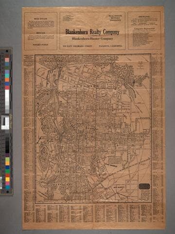
Map of Pasadena
Visual Materials
Map is untitled. Old shelf number: Eph J2d. Thurston kept updating his Pasadena map and the verso Road Map of Southern California. The latest statistics quoted are from 1921, hence the guess of 1922 for this maps date. MS note: Eph J2d. Prime meridian: GM. Relief: hachures. Graphic Scale: Feet. Projection: Plane. Printing Process: Lithography. Verso Text: Map ephMPCALIF0121.
ephMPCALIF0120

Revised edition road map of Southern California
Visual Materials
Old shelf number: Eph J2d. Thurston kept updating his Pasadena map and the verso Road Map of Southern California. The latest statistics quoted are from 1921, hence the guess of 1922 for this maps date. Prime meridian: GM. Relief: hachures. Graphic Scale: Miles. Projection: Cylindrical. Printing Process: Lithography. Verso Text: Map ephMPCALIF0120. MS note: Eph J2d.
ephMPCALIF0121
Image not available
Automobile road map of metropolitan Los Angeles
Visual Materials
Old shelf number Eph J2d. Insert map of "Congested District." Submap: Congested District of Los Angeles. Prime meridian: GM. Relief: hachures. Graphic Scale: Miles. Projection: Cylindrical. Printing Process: Lithography. Verso Text: Title cover. MS note: Eph J2d.
ephMPCALIFR0024
Image not available
Automobile road map of Southern California
Visual Materials
Old shelf number: eph J2d. This same map appears on the verso of several Los Angeles maps. At head of title: "Security Trust & Savings Bank." For earlier editions of this map, see RB ephMPCALIF0050 & ephMPCALIF0064; for a later edition, see RB ephMPCALIF0065; for another 1923 version, see RB 258713. Prime meridian: GM. Relief: no. Graphic Scale: Miles. Projection: Cylindrical. Printing Process: Lithography. Verso Text: MS note Eph J2d. Submaps: San Diego County; Ventura and Santa Barbara; Central California.
ephMPCALIFR0003
Image not available
Map of the City of Los Angeles / Security Trust & Savings Bank
Visual Materials
Old shelf number: eph J2d. Alternate title from verso. For an earlier edition, see RB ephMPCALIF0073. Red lines indicate best automobile routes around and through the city. Verso shows map of the "Shoestring" to the harbor and harbor lands. Second map shows city growth by annexation through 1918. Street Index and route descriptions. Prime meridian: GM. Relief: no. Graphic Scale: Miles. Projection: Cylindrical. Printing Process: Lithography. Verso Text: MS note: Eph J2d. Shoestring and expansion maps.
ephMPCALIF0071
Image not available
Principal automobile routes in and out of Los Angeles
Visual Materials
Old shelf number: Eph J2d. This map of central Los Angeles shows the Arroyo Seco Parkway and the beginnings of other freeways. The start of the San Bernardino Freeway is open from the Los Angeles River to City Terrace. Grand Central Airport is in operation in Glendale. Prime meridian: GM. Relief: hachures. Graphic Scale: Miles. Projection: Cylindrical. Printing Process: Lithography. Verso Text: Auto Club folding cover. MS note: Eph J2d.
ephMPCALIF0112