Opening Hours
Daily: 10 A.M.–5 P.M.
Closed on Tuesdays
1151 Oxford Road
San Marino, CA 91108
Visual Materials
Daily: 10 A.M.–5 P.M.
Closed on Tuesdays
1151 Oxford Road
San Marino, CA 91108

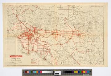
Visual Materials
Old shelf number: eph J2d. Paved roads are shown in red. Numbers in red circles are distances from Civic Center by nearest paved road. For another copy of this map, see RB ephMPCALIF0064; for later editions, see RB 258713, ephMPCALIF0065, & ephMPCALIFR0003. Prime meridian: GM. Relief: no. Graphic Scale: Miles. Projection: Cylindrical. Printing Process: Lithography. Verso Text: Submaps: San Diego County; California north from Los Angeles to Reno. Sales info for ACSC.
ephMPCALIF0050
Image not available
Visual Materials
No old shelf number. Comprehensive map of paved roads in the region shown in red. For earlier editions of this map, see RB 258713, ephMPCALIF0050, ephMPCALIF0064, and ephMPCALIFR0003. Prime meridian: GM. Relief: no. Graphic Scale: Miles. Projection: Cylindrical. Printing Process: Lithography. Verso Text: Three submaps: Routes in San Diego County; Ventura and Santa Barbara; Central California.
ephMPCALIF0065
Image not available
Visual Materials
Old shelf number: eph J2d. This same map appears on the verso of several Los Angeles maps. At head of title: "Security Trust & Savings Bank." For earlier editions of this map, see RB ephMPCALIF0050 & ephMPCALIF0064; for a later edition, see RB ephMPCALIF0065; for another 1923 version, see RB 258713. Prime meridian: GM. Relief: no. Graphic Scale: Miles. Projection: Cylindrical. Printing Process: Lithography. Verso Text: MS note Eph J2d. Submaps: San Diego County; Ventura and Santa Barbara; Central California.
ephMPCALIFR0003
Image not available
Visual Materials
Old shelf number: eph J2d. Key routes in red for 1920. For similar maps, see RB ephMPCALIF0091 and ephMPCALIF0092. Prime meridian: GM. Relief: no. Graphic Scale: Miles. Projection: Cylindrical. Printing Process: Lithography. Verso Text: MS note: Eph J2d. Complete City map and Harbor map.
ephMPCALIF0090
Image not available
Visual Materials
Old shelf number: eph J2d. Alternate title from verso. For an earlier edition, see RB ephMPCALIF0073. Red lines indicate best automobile routes around and through the city. Verso shows map of the "Shoestring" to the harbor and harbor lands. Second map shows city growth by annexation through 1918. Street Index and route descriptions. Prime meridian: GM. Relief: no. Graphic Scale: Miles. Projection: Cylindrical. Printing Process: Lithography. Verso Text: MS note: Eph J2d. Shoestring and expansion maps.
ephMPCALIF0071
Image not available
Visual Materials
Old shelf number Eph J2d. Bank branches shown in green. For a similar but undated copy of this map, see RB ephMPCALIF0078. Street Index. Prime meridian: GM. Relief: no. Projection: Cylindrical. Printing Process: Lithography. Verso Text: Charles Owen map of So. Calif.; Los Angeles and Long Beach Harbor.
ephMPCALIFR0025