Visual Materials
Map of Santa Monica California / by J. E. Jackson C.E
You might also be interested in

Map of Santa Monica California / by J. E. Jackson C.E
Rare Books
Submap notes showing the "proposed city" at the terminus of the Los Angeles and Independence Railroad, then in competition with the Southern Pacific Railroad for the location of Los Angeles Harbor. A gift of Robert D. Farquhar, June 1944. See also ephMPCALIF0041 for another copy on larger format. Submap: Map of Santa Monica Harbor showing site of proposed city Ocean Terminus of Los Angeles and Independence RailRoad 1875. MS note: 253359 Ms routing of pipeline from spring to possible reservoir. Prime meridian: GM. Relief: hachures. Projection: Plane. Printing Process: Lithography.
253359

Santa Monica, Los Angeles Co., Cal
Visual Materials
Image of the shoreline as seen from the roof of a railroad train at end of the Los Angeles and Independence Wharf with the Santa Monica Hotel on the Palisades bluffs and the Santa Monica Bath House on the beach below in Santa Monica, California.
photCL_555_09_90

Santa Monica Bath House
Visual Materials
Image of the Santa Monica Bath House in mid-distance, shacks, and tents on the beach in Santa Monica, California, with the bluffs at right and steps leading down to the remaining portion of the Los Angeles & Independence railroad wharf. A sign above one of the buildings reads "Lone Star Cane Rack."
photCL_555_01_3278

People on beach in front of the Santa Monica Bath House
Visual Materials
Image of people sitting on a beach wearing suit coats and hats in front of the Santa Monica Bath House in Santa Monica, California, with a portion of the Los Angeles and Independence Railroad Wharf visible in the distance.
photCL 555

North Beach and Railroad, Santa Monica
Visual Materials
Image of North Beach and the Arcadia Hotel with the Southern Pacific Railroad tracks running next to the Beach Road in Santa Monica, California, in 1893. The Santa Monica Bath House and the remains of the Los Angeles and Independence Wharf are visible at right and the Palisades Bluffs are visible at left.
photCL_555_01_1224
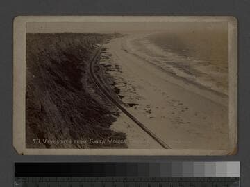
View south from Santa Monica Canyon
Visual Materials
Image of the cliffs and beach looking south from Santa Monica Canyon with the Arcadia Hotel in distance, and the Southern Pacific Railroad tracks running next to the Beach Road in Santa Monica, California. The remains of the Los Angeles and Independence Wharf are visible at upper right center of image.
photCL_555_01_1225