Visual Materials
To the Citizens of Philadephiia this Plan of the City and its environs is respectfully dedicated By the Editor
You might also be interested in
Image not available
Plan of the Island of Fernand de Noronha, from a French Survey, Compared with the Survey made by The Colchester man of war in 1760. Communicated by Mr. Norris of Liverpool
Visual Materials
Vignettes: Five vignettes of views of island.. Prime meridian: London. Relief: hachures. Graphic Scale: Miles. Projection: Plane. Watermark: Shield. Printing Process: Copper engraving. Other Features: Vignettes. Verso Text: MS note: 647.
093:647 M
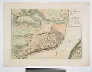
Plan of the City and Environs of Quebec with its Siege and Blockade by the Americans, from the 8th of December 1775 to the 13th of May 1776
Visual Materials
Kashnor notes, "A very fine war plan, in colours, showing where Montgomery made his attack and the emplacement of batteries." A stunning map. Kershaw supplies appeared in information. Relief: hachures. Graphic Scale: Yards. Projection: Plane. Watermark: Crowned fluer-di-lis W F. Printing Process: Copper engraving. References: Kershaw 1041; LC Phillips 1207,1337.. Verso Text: MS note: 120.
093:120 M

State of Rhode Island; compiled from the Surveys and Observations of Caleb Harris
Visual Materials
Kashnor notes, "The first issue of this map [1796], second issue was in 1818." McCorkle dates as 1795 and gives appeared in information. Wheat & Brun note state 1. MS notes: 581 Mus. Col. #93. Relief: no. Graphic Scale: Miles. Projection: Plane. Watermark: Device. Printing Process: Copper engraving. References: McCorkle R795.2; Wheat & Brun 250, state 1..
093:581 S

Plan of the Havana and its Environs with the several Posts and Attacks, made by the British Forces; under the Command of the Earl of Albemarle and Sr. Geo. Pocock: which was taken 13 Aug: 1762
Visual Materials
Relief: hachures. Graphic Scale: Miles, feet. Projection: Plane. Printing Process: Copper engraving. Verso Text: MS note: 752.
093:752 M
Image not available
Map of the State of Pennsylvania, by Reading Howell, MDCCXCII (1792)
Visual Materials
Kashnor notes, "The original issue of this map, with the declaration of Samuel Caldwell, dated, 'the eleventh day of January, in the fifteenth year of Independence of the United States of America.'" Wheat & Brun shows numerous states of this map. This appears to be state 2, but publication location is uncertain. Cartouche: wreath around dedication.. Prime meridian: Washington. Relief: hachures. Graphic Scale: Miles. Projection: Cylindrical. Printing Process: Copper engraving. Other Features: Cartouche. References: Wheat & Brun 434. Verso Text: MS note: 572/ Mus. Col. 93.
093:572 M

Sketch of the Operations before Charleston the Capital of South Carolina 1780
Visual Materials
Kashnor notes, "Shows the British warships bombarding the fort, and gives particulars of the forts, batteries, &c. of the opposing armies. 'Having surrendered by Capitulation the 12th May the Garrison laid down their Arms at I betwenn the Abbatis in front of the Hornwork.' Probably the earliest example of map engraving executed in South Carolina." [Ships shown are American and French, per "Dictionary of American Naval Fighting Ships."] This map State II per Wheat & Brun who identify published information, date. LC record shows Thomas Abernethie opened engraving & printing shop in Charleston, SC, ca. 1785. MS notes: 85 Mus. Col. #105 (on backing). Relief: hachures. Graphic Scale: Miles, statute. Projection: Plane. Watermark: Crowned shield. Printing Process: Copper engraving. References: Wheat and Brun 595. Verso Text: MS note: 85.
105:085 M