Rare Books
Klamath County, Oregon
You might also be interested in
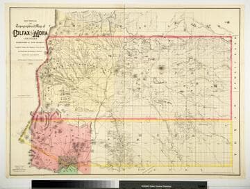
Sectional and Topographical Map of Colfax and Mora Counties Territory of New Mexico
Rare Books
Numerous changes have been made since the earlier map, 128069. "Compiled from the Original Plats in the Surveyor Generals Office Santa Fe, New Mexico. J. S. Taylor U. S. Deputy Surveyor, 1881." "Entered according to Act of Congress in the year 1882 by G.W. & C.B. Colton & Co. in the Office of the Librarian of Congress, at Washington." Prime meridian: GM. Relief: hachures. Graphic Scale: Miles. Projection: Cylindrical. Printing Process: Lithography. Verso Text: HL sticker: 128313.
128313
Image not available
Gunnison County, Colorado
Rare Books
Shows commercial mineral deposits within the county. Denver and Rio Grande Railroad complete. Mineral table. Sticker: 40. Prime meridian: GM. Relief: no. Graphic Scale: Miles. Projection: Cylindrical. Printing Process: Lithography. Verso Text: MS note: Sheet showing mineral & coal belts, Gunnison, Co. Sticker: 78.
283763
Image not available
Official map of Amador County, California / compiled by J.A. Brown, County Surveyor
Rare Books
Amador County then as now sparsely settled except on western side. Prime meridian: GM. Relief: shaded. Graphic Scale: Chains. Projection: Cylindrical. Printing Process: Lithography. Verso Text: Amador County 10 Sticker: Uncat. Amador Co. Official Map 1881.
477328
Image not available
Map of the Texas Santa Fe and Northern Railroad
Rare Books
Showing existing and projected railroads from Chicago to California. "Office, San Francisco Street, Santa Fe, New Mexico. October, 1882." "Copyright 1882 by Rand MaNally & Co." Prime meridian: GM. Relief: hachures. Projection: Cylindrical. Printing Process: Lithography. Verso Text: HL sticker: 128403.
128403
Image not available
Official Map of Lake County California
Rare Books
"Frank C. McIntire, Draftsman." "Compiled from Government and County Surveys and other reliable sources by D. F. McIntire, County Surveyor." Prime meridian: GM. Relief: shaded. Graphic Scale: Miles. Projection: Cylindrical. Printing Process: Lithography.
183629
Image not available
Map of Los Angeles County California S. of T.3.N. S.B. B.& M. and a part of Orange County W of R.&.W. S.B. B.& M
Rare Books
Blueline map with hand colored city and county borders. Submap: Northern part of Los Angeles County. Prime meridian: GM. Relief: hachures. Graphic Scale: Miles. Projection: Cylindrical. Printing Process: Blueline print. Verso Text: MS note: 477332 Sticker: Uncat. Map L.A. County Pt. of Orange Co. Rand-McN.
477332