Opening Hours
Daily: 10 A.M.–5 P.M.
Closed on Tuesdays
1151 Oxford Road
San Marino, CA 91108
Rare Books
Daily: 10 A.M.–5 P.M.
Closed on Tuesdays
1151 Oxford Road
San Marino, CA 91108

Rare Books
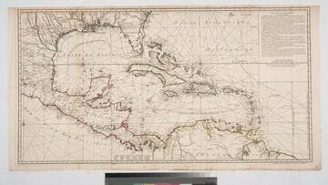
Patterned after Popple's map "with corrections and amendments." Discussion of miles, but no scale on the map itself. MS note: No.(5) 7. "Réduite de la Carte Angloise en 20 Suelles par Mr. Popple avec quelques Corrections et Augmentations par Phil. Buache ern 1740." Prime meridian: London, Paris. Relief: no. Projection: Cylindrical. Watermark: Lettering. Printing Process: Copper engraving. Verso Text: MS notes: 30 150094 dr/L2+2 10 pieces.
150094
Image not available
Visual Materials
Kashnor notes, "According to the draughtsman the Popple map was not in the proper latitude." Actually, it is a longitude error Buache is referring to. Buache has a long history of designing similar maps to show up errors of other mapmakers and enhance his own position. His map is printed in blue as an overlay of the Popple map printed in red. An early dual printed map. MS note: 252. Prime meridian: Ferro. Relief: no. Projection: Mercator. Watermark: Lettering. Printing Process: Copper engraving. Verso Text: MS note: 252 CDO (?).
093:252 S
Image not available
Visual Materials
Kashnor notes, "A very curious chart, purporting to represent the entire world, with the North Pole in the center. California appears as an island with 'Terres Inconnues, ou terre de Jesso,' lying across the North Pacific between America and China. South America also appears in a strangely truncated form, with Tierra del Fuego as a lengthy and very narrow island." Kashnor dates as [1714]. Several places in France and around the world are marked with *, noting places whose longitude has been measured using the satellites of Jupiter. Main title in upper left hand corner, alternate title in upper right hand corner. Elaborate allegorical figures surround the map. Prime meridian: Tenerife. Relief: pictorial. Projection: Polar. Printing Process: Copper engraving. Verso Text: MS note: 291.
105:291 M
Image not available
Rare Books
Kashnor notes, "Shows the Terre de Jesso almost touching California, the then existing idea of the passage between Asia and America. Locates the Terre de Quir, which though out of the longitude, resembles the Northern Coast of Australia. Shows also New Holland and the coast of New Zealand and Van Diemen's Land." Shirtley 550 says this map is the fourth plate of Sanson's original 1674 map and gives atlas source. Cartouches: elaborate upper and lower cartouches with mermen and sea creatures. "Par le Sr. Sanson Geographe Ordinaire du Roy 1691." "Presenté a Monsigneur le Dauphin, Par son tres-humble, tres-obeissant, et tres-fidele servuiteur, Hubert Jaillot." Prime meridian: Ferro. Relief: pictorial. Projection: Dual Hemisphere. Printing Process: Copper engraving. Other Features: Cartouche. References: Shirley 550, LC 524.. Verso Text: MS note: 148966.
148966
Image not available
Rare Books
Last voyage on the map is Cook's in 1779. Date provided is between then and Denis' death in 1794. Brilliant coloring of the four continental representations. Multiple repairs to verso. Vignettes: Four continents; Celestial views. Prime meridian: Paris. Relief: pictorial. Projection: Dual Hemisphere. Printing Process: Copper engraving.
281742
Image not available
Visual Materials
Kashnor notes, "Shows California as an island, and inserts 'Terre de Jesso ou Je co' between 40 deg. and 50 deg." This map was originally drawn from Sanson's model in 1674. Since this copy is undated, Shirley suggest it is State 3 of Plate IV, done after 1696. Cordier sc. missing this state. Elaborate cartouche of putti on dolphins, mermen below.. Prime meridian: Ferro. Relief: pictorial. Projection: Dual Hemisphere. Printing Process: Copper engraving. Other Features: Cartouche. References: Shirley 462; BL 150.e13; Wagner 409a.. Verso Text: MS note: 246.
105:246 M