Rare Books
Map of the Cañadas de los Capitancillos and adjacent hills and mountains including the lands of New Almaden / surveyed by Wm. J. Lewis C.E drawn by Vitus Wackenreuder

You might also be interested in
Image not available
City and County of San Francisco : compiled from official surveys and sectionized in accordance with U.S. Surveys / drawn by V. Wackenreuder, C.E. 1862
Rare Books
This map belongs with the "Directory for 1862." Submaps: Farrallone Islands. Seal of City & County of San Francisco. Prime meridian: GM. Relief: hachures. Graphic Scale: Miles. Projection: Plane. Printing Process: Lithography.
64982a

Map of the Excelsior Homestead Association / surveyed by Vitus Wackenreuder
Visual Materials
Old shelf number: eph J4-3 (4). Many MS notes on lot pricing. At the north end of today's Excelsior neighborhood. The streets named after cities have not been renamed, but some of the streets named after countries have. Prime meridian: GM. Relief: no. Graphic Scale: Feet. Projection: Plane. Printing Process: Lithography. Verso Text: MS notes: Excelsior H.A.
ephMPCALIFT0041
Image not available
Official Map of Fresno County California / compiled from Official surveys and records by J. C. Shepard, C.E. 1886
Rare Books
A very large map in two sheets. Submaps: Selma, . Prime meridian: GM. Relief: hachures. Graphic Scale: Miles, chains. Projection: Cylindrical. Printing Process: Lithography.
273058
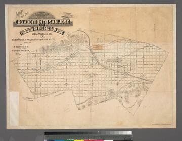
Map of the subdivision of the Ro. addition to San Jose and portion of the Ro. San Jose Los Angeles Co., Cal.; subdivided at the request of San Jose Ro. Co. April 1887 / by B. Bassell, C.E.; field-work by Arthur Philbrick, Sur
Rare Books
Map of the area of San Dimas. MS note: 384612 numerous lot notes. Edge bound. Prime meridian: GM. Relief: hachures. Graphic Scale: Chains. Projection: Plane. Printing Process: Lithography.
384612
Image not available
Map of the copper mines of Calaveras County : from actual survey and measurement / surveyed and drawn by Handy & Wallace, Civil Engineers
Rare Books
Contains a Sectional view of the Reed Lode. MS note : 350-. Prime meridian: GM. Relief: hachures. Graphic Scale: Miles, feet. Projection: Plane. Printing Process: Lithography.
471221
Image not available
Map of Corona Riverside County California / compiled by H. Clay Kellogg, C.E
Visual Materials
Old shelf number: eph J4-11(1). See also 356004 for an earlier map of Corona. This is a duplicate of 356005 on which an MS note on this map suggests the 1909 date for this map. MS notes: eph J4-11 (1). Prime meridian: GM. Relief: hachures. Graphic Scale: Chains. Projection: Plane. Printing Process: Lithography.
ephMPCALIF0019