Rare Books
United States
You might also be interested in
Image not available
United States, by J. Arrowsmith
Visual Materials
Kashnor notes, "The most westerly states are Missouri, Arkansas and Louisiana. Wisconsin is called North-West Territory, or Huron. and the map takes in the Minnesota country beyond Red River, locating Pembina." Prime meridian: London. Relief: hachures. Graphic Scale: Miles. Projection: Pseudocylindrical. Printing Process: Copper engraving. Verso Text: MS note: 602 Two of eighteen segments have green cloth backing..
093:602 M
Image not available
United States and additions, 1820
Rare Books
Kashnor notes, "Embodies the discoveries of Lewis and Clark, and gives a detailed representation of the Missouri Territory, New Mexico, California, &c. It is a vert fine map, and probably the best published at that time." Kashnor dates as [1821]. Indistinct note left margin. No. 55 (upper right). Prime meridian: GM. Relief: hachures. Projection: Conic. Printing Process: Copper engraving. Verso Text: MS note: 148968.
148968
Image not available
Upper Territories of the United States
Visual Materials
Kashnor notes, "One of the earliest maps showing Illinois, Indiana, Ohio and Michigan [lower peninsula] as definite states. The Wisconsin and part of Minnesota territories are still called Western Territory, in which Chicago is still located." Kashnor dates as ca. 1813. Prime meridian: Philadelphia. Relief: hachures. Graphic Scale: Miles. Projection: Cylindrical. Printing Process: Copper engraving. Verso Text: MS note: 546.
093:546 M
Image not available
Map of the United States of America with its territories and districts : Including also a part of Upper & Lower Canada and Mexico
Rare Books
A map in two sheets. Mexico extends through California and Texas. Vignettes: White House; Capitol; Tables of population and distances. Prime meridian: Washington. Relief: hachures. Graphic Scale: Miles. Projection: Pseudocylindrical. Printing Process: Copper engraving. Verso Text: MS note: 264296.
264296
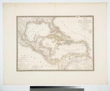
Carte des Iles Antilles ou Indes Occidentales, du Golfe du Mexique. et d'une partie des Pays Adjacents
Visual Materials
"par A. Brué Geographe du Roi." "Gravee sous le direction de l'Auteur." "Atlas Universel." "Pl 55" Prime meridian: Paris. Relief: hachures. Graphic Scale: Leagues, miles. Projection: Conic. Printing Process: Copper engraving. Verso Text: MS note: 946.
105:946 M
Image not available
New and Accurate Plan of the River St. Lawrence, from the Falls of Montmorenci to Sillery, with the Operations of the Siege of Quebec 1763
Visual Materials
This map appears to be a reduced size copy of Jefferys' map, 093:325 and 093:325A. The engraving is less detailed. Submap of Sep. 13 1759. MS note: 329A (on backing). Relief: hachures. Graphic Scale: Miles. Projection: Plane. Printing Process: Copper engraving. Other Features: Sub-maps. Verso Text: MS note: 329A (on backing).
093:329A S