Rare Books
Rare Books
Daily: 10 A.M.–5 P.M.
Closed on Tuesdays
1151 Oxford Road
San Marino, CA 91108

Image not available
Rare Books
See also Museum Bookstore map 105:478, described as follows: Kashnor notes, "Shows the course of the Missouri extending north of the Rockies, where the Spaniards forded the river to trade with the people for yellow iron, "du fer jaune." Also shows Carolina, Virginia, Maryland, and New Mexico." Kashnor dates as ca. 1720. This edition shows New Orleans. Sub map of the Mississippi delta. See 093:550M for an earlier version and 52352 for a reproduction. Sub map: Carte Particuliere des Embouchures de la Riviere S. Louis et de la Mobile. "Dresée sur un grand nombre de Memoires entr autres sur ceux de Mr. le Maire Par Guillme. de l'Isle de l'Academie Rle. des Sciences." Prime meridian: Ferro. Relief: pictorial. Graphic Scale: Leagues. Projection: Cylindrical. Printing Process: Copper engraving. Verso Text: MS notes: 150047 La Louisiane & Cours du Mississipi.
150047
Image not available
Visual Materials
Kashnor notes, "Shows the course of the Missouri extending north of the Rockies, where the Spaniards forded the river to trade with the people for yellow iron, "du fer jaune." Also shows Carolina, Virginia, Maryland, and New Mexico." This edition does not show New Orleans. Submap of the Mississippi delta. Appeared in information from RLIN record. See 105:478M for a later version and RB 52352 for a reproduction. Submap: Carte Particuliere des Embouchures de la Riviere S. Louis et de la Mobile. Prime meridian: Ferro. Relief: pictorial. Graphic Scale: Leagues. Projection: Cylindrical. Printing Process: Copper engraving. Verso Text: MS note: 550.
093:550 M
Image not available
Visual Materials
Kashnor notes, "Shows the course of the Missouri extending north of the Rockies, where the Spaniards forded the river to trade with the people for yellow iron, "du fer jaune." Also shows Carolina, Virginia, Maryland, and New Mexico." Kashnor dates as ca. 1720. This edition shows New Orleans. Submap of the Mississippi delta. MS note: 41 (upper right). Appeared in information from RLIN record. See 093:550M for an earlier version, 150047 for the same version, and 52352 for a reproduction. Submap: Carte Particuliere des Embouchures de la Riviere S. Louis et de la Mobile. Prime meridian: Ferro. Relief: pictorial. Graphic Scale: Leagues. Projection: Cylindrical. Printing Process: Copper engraving. Verso Text: MS note: 478.
105:478 M
Image not available
Rare Books
Kashnor notes, "... An important and scarce map of Ksmtschatka and Russian America, with the tracks of the explorers." [contains also Swartz letter of 13 January, 1740 in French and Dutch] "Rectifier selon la Carte de Monsieur Jean Kyrilow, premier Secretaire du Consiel de l'Empire de Russie publier en l'Anne 1734 ou on trouve le Pais de Kamschatka, d'ou le Captaine Spanberg a fait voile, comme la copie de Lettre si jointe par le Resident Hollandois Monsieur Swatrz a St. Petersbourg en fait mention." Prime meridian: Ferro. Relief: pictorial. Projection: Polar. Watermark: CS?. Printing Process: Copper engraving. Verso Text: MS notes: 4th N23/93 148972.
148973
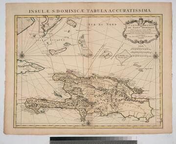
Rare Books
Prime meridian: Ferro. Relief: pictorial. Graphic Scale: Leagues. Projection: Cylindrical. Watermark: W M. Printing Process: Copper engraving. Verso Text: MS note: L'Isle de St. Dominique.
295823
Image not available
Rare Books
Map famous for native boatmen paddling in opposite directions and for sunken birds swimming in open ocean. Also for imaginary Pepys Island off Argentina. Cartouche: Natives. Prime meridian: Ferro. Relief: pictorial. Graphic Scale: Leagues. Projection: Pseudocylindrical. Watermark: W M. Printing Process: Copper engraving. Verso Text: MS notes; Paraguay Chili.
295822