Opening Hours
Daily: 10 A.M.–5 P.M.
Closed on Tuesdays
1151 Oxford Road
San Marino, CA 91108
Visual Materials
Daily: 10 A.M.–5 P.M.
Closed on Tuesdays
1151 Oxford Road
San Marino, CA 91108

Image not available
Visual Materials
Kashnor notes, "Shows Cook's tracks in the South Seas and to the North-West Coast of America. Locates Drake's Harbour and New Albion." Atlas reference from Rosenthal. Also shows tracks of Bouganville in 1768, Byron in 1765. See also 105:019M for an earlier version of this map (1781). Numeral 2 in upper right, lower right outside neatline. Also 093-190S for later version. Compass rose lower center.. Prime meridian: London. Relief: pictorial. Graphic Scale: Sea leagues 20 in a Degree. Projection: Mercator. Printing Process: Copper engraving. Other Features: Art Work. References: Phillips (A)659-2; Marshyall I-301-2-1 [from Rosenthal 1996]. Verso Text: MS. note:93 62; II.
093:062 M
Image not available
Visual Materials
Kashnor notes, "Shows the North-West Coast and Part of Kamtschatka, also Australia and New Zealand." Shows tracks of Cook's voyages. Prime meridian: GM. Relief: pictorial. Graphic Scale: No. Projection: Dual Hemisphere. Watermark: Fleur-de-lis, VI. Printing Process: Copper engraving. Verso Text: MS. note: 34.
093:034 M
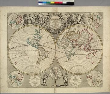
Visual Materials
Kashnor notes, "Shows the Strait of Anian and California as an Island, also New Holland, Van Diemen's Land, and part of New Zealand." Kashnor notes ca. 1719. Senex worked in London. Cartouche with angels and female figures. Two males below by armillary sphere. Four sub-maps, two on plane of Equator [polar views], two on the plane of London. one centered on London's antipode. Two depictions of climate zones.. Prime meridian: London. Relief: pictorial. Graphic Scale: No. Projection: Dual Hemisphere. Printing Process: Copper engraving. Other Features: CartoucheSub-mapsFigures . Verso Text: MS. notes: 93; 48; ~1719.
093:048 M
Image not available
Visual Materials
Kashnor notes, "Shows a good coastline to the North-West and Alaska, locating New Albion, Nootka Sound, River of the West, and shows Cook's track to Icy Cape." Prime meridian: Ferro. Relief: pictorial. Graphic Scale: No. Projection: Dual Hemisphere. Printing Process: Copper engraving.
105:034 M
Image not available
Visual Materials
[See also 105-261 not duplicate per folder.] Kashnor notes, "Gives a particularly good coastline from California to Alaska." See 093:043M, 093:062M, 105: 019 for earlier versions of this map. Printed 2 top and bottom right corners, MS note: 2. Prime meridian: London. Relief: pictorial. Projection: Mercator. Printing Process: Copper engraving. Verso Text: MS note: 190.
093:190 S
Image not available
Visual Materials
Kashnor notes," On the North-West Coast the line only reaches to Northern California, which is represented as an island. Part of New Zealand and New Holland is also shown." Kashnor dates as [1698], Shirley dates 1700-01. This is the second world map in Wells' atlas, 093:047M is the first similar map from the same atlas, per Shirley. Cartouche of figures representing continents and views of Oxford.. Prime meridian: London. Relief: no. Graphic Scale: No. Projection: Dual Hemisphere. Printing Process: Copper engraving. Other Features: CartoucheVignettes. References: Shirley 609.. Verso Text: MS. note: 198.
093:198 M