Rare Books
A map of the British and French settlements in North America / Univ. Mag. J. Hinton Newgate Street
You might also be interested in
Image not available
A map of the British and French settlements in North America
Visual Materials
Kashnor notes, "Locates all the French forts in the Ohio and Louisiana territories. A scarce map, issued as a supplement to a magazine during the Old French War." Variant of 105:662. RLIN record gives date and appeared in information. Shows separate North and South parts of South Carolina. Submap: Fort Frederick at Crown Point built by the French in 1731. [Lake Champlain]. MS note: 297 (on backing). Prime meridian: London. Relief: no. Projection: Mercator. Watermark: Crowned GR Lion rampant in seal. Printing Process: Copper engraving. Verso Text: MS note: 297 (on backing).
093:297 S
Image not available
A new and accurate map of the present war in North America / Universal Mag. J. Hinton
Rare Books
MS notes: Maps N.A. T. Cat 4/ 648 41123. Prime meridian: London. Relief: pictorial. Projection: Cylindrical. Watermark: Two seals. Printing Process: Copper engraving.
41123
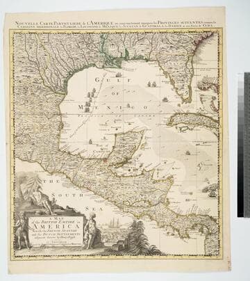
Map of the British Empire in America With the French, Spanish and the Dutch Settlements adjacent thereto by Henry Popple
Visual Materials
Kashnor notes, "Copied from Popple's map With the titles in English and French. ShoWs Carolina divided into counites, With Georgia and the Forts neWly erected, and Savannah." Kashnor dates as ca. 1740, RLIN record suggests 1755. Cartouche of Indians, traders. MS note: No. 10. Relief: pictorial. Projection: Cylindrical. Printing Process: Copper engraving. Other Features: Cartouche. References: McCorkle [741.2]. Verso Text: MS note: 326.
105:326 M
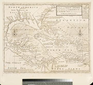
Chart of the West Indies or the Islands of America in the North Sea &c. Being the Present Seat of War. by Herman Moll Geographer
Visual Materials
Kashnor notes, "Shows the mainland around the Gulf of Mexico, with Louisiana, Florida, Georgia, and Carolina." Kashnor dates as ca. 1719. Submap: Vera Cruz harbor. Sailing instructions for galleons. MS note: 321 (on backing). Prime meridian: London. Relief: no. Projection: Cylindrical. Watermark: Two devices. Printing Process: Copper engraving. Other Features: Sub-maps.
105:321 S
Image not available
A New and Accurate Map of the English Empire in North America: Representing their Rightful Claim as confirmed by Charters, and the formal Surrender of their Indian Friends; Likewise the Encroachment of the French, with the several Forts thery have unjustly erected therein. By a Society of Anti-Gallicans
Visual Materials
Kashnor notes, "Indicates by the use of different colours, the territory in dispute, which includes the greater part of the continent of North America, and shows the boundaries of the Carolinas, Georgia, and Virginia reaching far west beyond the Mississippi." Contains submap. Submap of extended territory, Hudson's Bay to South America.. Prime meridian: London, Ferro. Relief: pictorial. Projection: Pseudocylindrical. Watermark: Fleur-di-lis on shield W. Printing Process: Copper engraving. Other Features: Sub-maps. References: McCorkle 755.38. Verso Text: MS note: 667.
105:667 M
Image not available
Map of North America; published under the Patronage of the Duke of Orleans by D'Anville. Drawn and Engraved for J. Harrison, No. 115, Newgate Street, January 1 1791
Visual Materials
Kashnor notes, "Shows north-west to Lake of the Woods, with a good outline of the Illinois country, locating the Aiaouez (Iowa) village on the river of the same name, a tributary of the Missouri, located in about the present position of Sioux City." Submap of Hudson's and Baffin Bays.. Prime meridian: Ferro. Relief: pictorial. Graphic Scale: Leagues, miles. Projection: Azimuthal. Printing Process: Copper engraving. Other Features: Sub-maps. Verso Text: MS note: 419.
093:419 M