Rare Books
[World map]
You might also be interested in
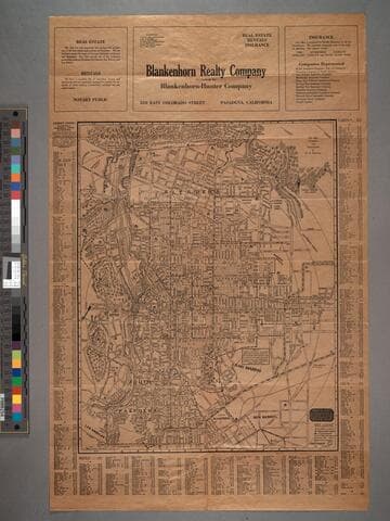
Map of Pasadena
Visual Materials
Map is untitled. Old shelf number: Eph J2d. Thurston kept updating his Pasadena map and the verso Road Map of Southern California. The latest statistics quoted are from 1921, hence the guess of 1922 for this maps date. MS note: Eph J2d. Prime meridian: GM. Relief: hachures. Graphic Scale: Feet. Projection: Plane. Printing Process: Lithography. Verso Text: Map ephMPCALIF0121.
ephMPCALIF0120
Image not available
Southampton 1846
Rare Books
A color photo-reproduction of the original map, pages 25, 26, and 28. Relief: no. Graphic Scale: Feet. Projection: Plane. Printing Process: Photo reproduction.
423600
Image not available
Map of the Upper District of Henrico County ; Map of the Lower District of Henrico County
Rare Books
Two maps on one sheet to allow better representation of this long narrow county. Lithographic reproduction of original map. Date is that of the original map. "Constructed partly from Govt. Maps and partly from Original Surveys, and drawn to a scale of two inches to a mile or 1/2 mile to the inch. The double lines represent roads and the irregular black lines represent streams. Railroads are indicated by red lines." "THIS MAP IS REDUCED TO ONE-THIRD OF ORIGINAL SCALE." Prime meridian: GM. Relief: no. Graphic Scale: Miles. Projection: Plane. Printing Process: Lithography. Verso Text: Huntington Library sticker: 116764 .
116764
Image not available
Birthplace of Washington : from a survey by A. Lindenkohl, 1879
Rare Books
Later reproduction of a famous map. MS note: 90827. Relief: no. Graphic Scale: Miles, yards. Projection: Plane. Printing Process: Lithography. Verso Text: MS note: 90827.
90827
Image not available
Long Island Sounde / by Robert Ryder
Rare Books
Reproduction. A John Carter Brown Library facsimile of this manuscript map. Broadsheet of explanation accompanies the map. Prime meridian: GM. Relief: no. Graphic Scale: Miles. Projection: Plane. Printing Process: Lithography. Verso Text: MS note:281744.
281744
Image not available
The Vinland map : a world map of about 1440, the oldest known map showing American lands
Rare Books
A reproduction of the controversial map. Explanation of the map. Relief: no. Printing Process: Lithography.
402177