Opening Hours
Daily: 10 A.M.–5 P.M.
Closed on Tuesdays
1151 Oxford Road
San Marino, CA 91108
Rare Books
Daily: 10 A.M.–5 P.M.
Closed on Tuesdays
1151 Oxford Road
San Marino, CA 91108

Image not available
Rare Books
McCorkle dates to 1724 (map 724.1). Cartouche: Native and trader. Prime meridian: Ferro. Relief: pictorial. Graphic Scale: Miles. Projection: Cylindrical. Watermark: Device over H. Printing Process: Copper engraving. Verso Text: MS notes: MXIV 50 230 Amer. 8 152834.
152834
Rare Books
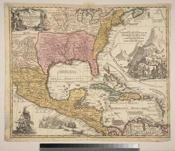
These notes from Museum Bookstore collection 105:571, another copy. Kashnor notes, "Gives a good map of New Mexico, locating Santa Fe and Taos; also shows the old boundaries of Louisiana." Kashnor dates as ca. 1730. Derived from L'Isle map. See 093:470M for another copy. This copy seems earlier with better detailing. Cartouche: Natives & trade goods. Vignettes: Sea battle; Merchants & Indians. Brown pen lines under many names. MS notes: very curious 1690 4011. Mat sticker: 819. Prime meridian: Ferro. Relief: pictorial. Graphic Scale: Miles. Projection: Pseudocylindrical. Printing Process: Copper engraving. References: Philips, Atlases, 3474; Lowery, no 473. Verso Text: MS notes: AD 1690 gift of -- 150049.
150049
Image not available
Rare Books
Kashnor notes, "Shows the Illinois country and Hennepin's route, with the old trading route to Aiaouex, locating the town somewhere in the neighborhood of the present Iowa State at Sioux City." Subview of beavers copied from Moll. Distorted idea of a buffalo. Kashnor dates as ca. 1720. See 093:416 for another copy and source of these notes. View of Niagara Falls copied from Moll; Cartouche with priest and native; Indians with "buffalo" looking more like cows than bison. Prime meridian: Ferro. Relief: pictorial. Graphic Scale: Miles, Leagues. Projection: Cylindrical. Printing Process: Copper engraving. Verso Text: MS note: 44194. References: McCorkle, map 720.1.
44194
Visual Materials
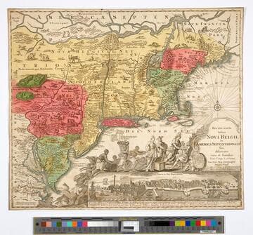
Kashnor notes, "This is Lotter's issue of Seutter's map, with the New York view showing the city in 1673, which had been issued about 1730. The plate had been engraved in 1680 for Allard [or Jansson] and had evidently passed into the hands of Seutter, afterwards acquired by Lotter." McCorkle identifies Seutter map as being printed in 1730, this is a later version. Cartouche: Figures paying homage. Vignette: New York in 1673. Numerous figures and animals. Prime meridian: Ferro. Relief: pictorial. Graphic Scale: Milliaria. Projection: Mercator. Printing Process: Copper engraving. References: McCorkle 730.4. Verso Text: MS note: 587.
105:587 M
Image not available
Rare Books
Note Florida extends north to Lake Erie. Map was first printed in 1714 and in 1730 "Cum Privilegio Sac. Caes. Majest." was added beneath "Norimbergae" (Cumming, map 156). Cartouche: Traders and Natives. MS note: 1674-1724. Prime meridian: Ferro. Relief: pictorial. Graphic Scale: German miles. Projection: Cylindrical. Printing Process: Copper engraving. Verso Text: MS notes:(1759) From Homann Atlas Geographicus Major Nuremberg 1759. La Virginia -- 142.
194332
Image not available
Rare Books
Badly colored cartouche. Cartouche: natives and animals. MS notes: 41 doss/20.00 c1731 1753 1762(?). Prime meridian: Ferro. Relief: pictorial. Projection: Pseudocylindrical. Watermark: Crowned device. Printing Process: Copper engraving. Verso Text: Ms note: 60.
493933