Visual Materials
Tabula Magellanica : quâ Tierrae del fuego, cum celeberrimis fretis a F. Magellano et I. Le Maire detectis novissima et accuratissima descriptio exhibetur
You might also be interested in
Image not available
Freti Magellanici ac novi Freti vulgó le Maire exactissima delineatio
Visual Materials
Kashnor notes, "With the representation of a gigantic Patagonian with a Spaniard beside him, the latter's head being on a level with the Patagonian's waist." Kashnor dates as ca. 1635. Based on pagination and language on verso, Van der Krogt dates to 1631 (9950:2A.2). Cartouche: framed. Figures of Patagonian with Spaniard, penguins, sea lions. Relief: pictorial. Graphic Scale: Miliaria. Projection: Cylindrical. Printing Process: Copper engraving. Verso Text: Printed description: Fretum le Maire; Fretum Magellanicum. Description in Latin. MMMMMMM. MS note: 937.
105:937 M
Image not available
Novissima et accuratissima totius Americae descriptio / per N. Visscher
Visual Materials
Kashnor notes, "Shows California as an island, with the supposed Strait of Anian much to the north. In the interior of the South American continent is depicted a desperate battle between two troops of Indians, armed with bows and clubs, also an Indian town, and a native gentleman peacefully sleeping in a hammock. Dedicated to Cornelius Witsen, with armorial bearings and emblematic figures." McLaughlin dates as 1670 and places in Amsterdam, as appeared in information. RLIN record dates as 1680? Variant of RB 139317, originally 093:209. Cartouche with Indians. Dedication with angels. Prime meridian: Tenerife. Relief: pictorial. Projection: Azimuthal. Printing Process: Copper engraving. References: McLaughlin 48; Phillips 507,508,3078; Wagner 378; Tooley 29 (Plate 41); Leighly 33 and 56 (Plate XI); Burden, map 332. Verso Text: MS note: 285.
105:285 M

Novissima et Accuratissima Insulae Jamaicae Descriptio per Johannem Sellerum. Hydrographum Regium Londini
Visual Materials
A catalogue of settlers and their locations. Kashnor dates as [1675]. See 093:802 for another copy. Cartouche: Coat of Arms, figures, empty dedication cartouche. Table: A Catalogue of the Severall Precincts, with the most Eminent Settlements therin, marked and numbered as followeth. Relief: pictorial. Graphic Scale: Miles. Projection: Cylindrical. Printing Process: Copper engraving. Other Features: Cartouche. Verso Text: MS note: 463.
105:463 M
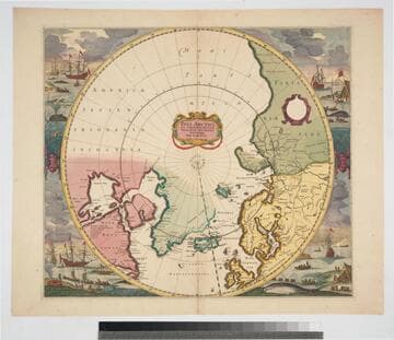
Poli Arctici, et circumiacentium terrarum descriptio novissima / per F. de Wit
Visual Materials
Kashnor notes, "Shows Hudson's Bay before the advent of the Company. The map followed that given by Capt. Thomas James." Kashnor dates as "c. 1670." Canadian archives date map to 1715. Whaling and sealing scenes each corner, beautifully colored. Prime meridian: Ferro. Relief: no. Projection: Polar. Printing Process: Copper engraving. Verso Text: MS notes: 242 C16u.
093:242 M

Novissima et Accuratissima Insulae Jamaicae Descriptio per Johannem Sellerum. Hydrographum Regium Londini
Visual Materials
A catalogue of settlers and their locations. Kashnor dates as [1675]. See 105:463M for another copy. Cartouche: Coat of Arms, figures, dedication cartouche. Table: A Catalogue of the Severall Precincts, with the most Eminent Settlements therin, marked and numbered as followeth. Relief: pictorial. Graphic Scale: Miles. Projection: Cylindrical. Watermark: Device possible lettering. Printing Process: Copper engraving. Other Features: Cartouche. Verso Text: MS notes: 802 29.
093:802 M
Image not available
Novissima et accuratissima totius Americae descriptio / per N. Visscher
Rare Books
Kashnor notes, "On the North-West coast it shows the supposed Strait of Anain. California is represented as an island, and it locates Capes Mendocino on Forturas, and New Albion." McLaughlin dates as 1670 and places in Amsterdam, and appeared in information. RLIN record dates as 1680? Burden suggests a date of ca. 1658. See also 105:285 for another copy. Cartouche with Indians. Dedication to Cornelis Witsen, father of the more famous Nicolaas Witsen. Dedication surrounded by angels. MS note: 60 (upper left). Prime meridian: Tenerife. Relief: pictorial. Projection: Azimuthal. Printing Process: Copper engraving. References: McLaughlin 48; Phillips 507,508,3078; Wagner 378; Tooley 29 (Plate 41); Leighly 33 and 56 (Plate XI). Verso Text: MS note: Cat 93 209.
139317