Visual Materials
Americae mappa generalis : secundum legitimas projectionis stereographicae regulas relationes que recentissimas et observationes Sociorum. Acad. reg. sequae Parisiis est aliorumque auctorum nec non secundum mentem / D. I.M. Hasii M.P.P. in partes suas methodicas divisa nunc concinnata et delineata ab Aug. Gottl. Boehmio Phil Magistro In lucem proferentibus. Homanniaris Heridibus
You might also be interested in
Image not available
Americae mappa generalis : secundum legitamas projectionis stereographicae regulas relationesque recentissimas et observationes sociorum Acad. reg. sequae Parisiis est aliorumque auctorum nec non secundum mentem / D. I.M. Hasii MP.P. in partes suas methodicas divisa nunc concinnata et dilenata ab Aug. Gottl. Boehmio. Phil. Magistro
Visual Materials
Kashnor notes, " Shows the North-West Coast to the supposed entrance of Martin d'Aguilar, locating P. du Drak, Port Monterey, Nova Albion, etc." Peninsular California. This map appears to be a partial remake of map 105:194M. Cartouche is somewhat cruder and lettering is redone. See 093:148M for another remake of this map. Elaborate cartouche. Note differences between this and 093:148 and 105:194. Each appears to have been done separately.. Prime meridian: Ferro. Relief: pictorial. Projection: Steriographic. Printing Process: Copper engraving. Other Features: Cartouche. References: Wheat 237. Verso Text: MS notes: 179.
093:179 M
Image not available
Americae mappa generalis : secundum legitimas projectionis stereographicae regulas relationesque recentissimas et observationes sociorum Acad. reg. sequae Parisiis est aliorumque auctorum necnon secundum mentem / D. I. M. Hasii MP.P. in partes suas methodicas divisa nunc concinnata et delineata ab Aug. Gottl. Boehmio Phil. Magistro
Visual Materials
Kashnor notes, "Shows the west coast of America as far as the northern frontier of California. The northern part of California is called New Albion, and it locates Port du Drak and Monterey. Florida and Louisiana reach to the Rockies." Peninsular California. See also 093:148M, an apparent remake of this map. See also 093:179M for another remake. Cartouche is much more detailed on this map, other minor differences. Elaborate cartouche. Prime meridian: Ferro. Relief: pictorial. Projection: Steriographic. Printing Process: Copper engraving. Verso Text: MS notes: 194. Partial transfer of title "Amerique" from another map.
105:194 M
Image not available
Tab. Geogr. Americae ad emendatiora quae adhuc prodierunt exampla jussu. Acad. Reg. Scient et eleglitt Boruss descripta
Visual Materials
Kashnor notes, "The North-West Coast reaches north to Cape Blanco, after which is the doubtful coast and entrance of Martin d'Aguilar. Locates Pt. du Drak and Nova Albion." Rosenthal identifies maker, dates as [c. 1753] and notes map was made for the Royal Prussian Academy. Cartouche with palm and initials v el. Prussian seal lower right. MS note: 212 (on backing).. Prime meridian: Ferro. Relief: pictorial. Projection: Steriographic. Watermark: Monogram. Printing Process: Copper engraving. Other Features: Cartouche.
093:212 S
Image not available
America septentrionalis : concinnata juxta observationes Dnn Academiae Regalis Scientiarum et nonnullorum aliorum, et juxta annotationes recentissimas / per G. de l'Isle, geographum
Visual Materials
Kashnor notes, "Shows California with the Gulf only extending a short distance North of the Gila. Locates New Albion, P. de Drak, and Sierra Nevada." Kashnor dates as ca. 1755, notes Cologne as place of publication. RLIN record suggests date as 1772. MS note: 7 top center, other penciled notes. Prime meridian: Ferro. Relief: pictorial. Graphic Scale: Miles, various. Projection: Pseudocylindrical. Printing Process: Copper engraving. Verso Text: MS notes: 153 c1755.
093:153 M
Image not available
Map of North America by J. Palairet With considerable Alterations & Improvements from D'Anville, Mitchell & Bellin. by L. Delarochette. 1765
Visual Materials
Kashnor notes, "North of New Albion we have 'Opening discovered by Martin d'Aguilar in 1603,' forming the mouth of the 'River of the West.' Further north is 'Opening discovered by Juan de Fuca in 1592. In this opening is an Island With a High Mountain in the Form of a Pillar.' This map locates the Indian nations, and shows the chain of forest around the Great Lakes." Note this is probably the first state of map 105:237, and the one covered by the RLIN record. Table of European holdings.. Prime meridian: Ferro. Relief: pictorial. Graphic Scale: Miles, leagues (inaccurate). Projection: Pseudocylindrical. Watermark: IHS Willedary Device With sub VC. Printing Process: Copper engraving. Other Features: Cartouche.
105:237A M
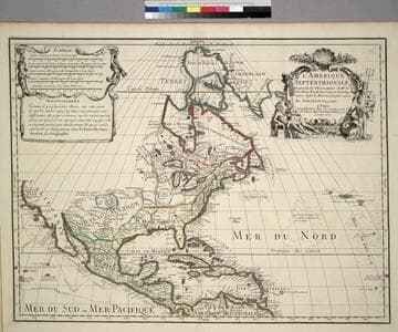
L'Amerique Septentrionale, Dresée sur les Observations de. Mrs. de l'Academie Royale des Sciences. & quelques autres, & sur les Memoires les plus recens
Visual Materials
Kashnor notes, " Shows the Gulf of California reaching only as far north as the Bona Guia River, the north-west coast has its limit at Cap Mendocin. It locates the Sierra Nevada Mountains, Port de Drak and New Albion, and also the tracks of Cortez, Drake, Olivier, Mendana and Gaetana. One of the best maps to show the geographical knowledge of California at the beginning of the 18th century." George Carhart of Osher Map Library confirms this map to be state 2, published in [1701]. See 093:160M for a later version of this map. Cartouche and figured scale bar. Includes Avertissement.. Prime meridian: Ferro. Relief: pictorial. Graphic Scale: Leagues, various. Projection: Pseudocylindrical. Watermark: Chained Maltese cross. Printing Process: Copper engraving. Other Features: CartoucheFigures . Verso Text: MS notes: 72 (on folded left edge); 159 Mus. Bk St. 93/159 25.
093:159 M