Visual Materials
Dominia Anglorum in America Septentrionali : specialibus mappis Londini primum a Mollio edita ; nunc recusa / ab Homannianis Hered. (juncta est majpulae [sic] D. facies ejus regionis quam Coloni Salisburg in colunt)
You might also be interested in
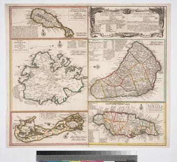
Dominia anglorum in preacipuis insulis Americae : ut sunt insula St. Christophori Antego Jamaica Barbados nec non insulae Bermudos vel Sommer dictae singulari mappa omnia exhibita et edita / ab Homannianus Heredibus. Cum Privil. Sac. Caes. Majestatis
Visual Materials
Kashnor notes, "a scarce map. five maps on one sheet." Map title is both Latin and German, place names on maps in English. Kashnor dates as c. 1750, publication in Nuremberg. See 105:182M for another state of this map, possibly earlier. RLIN record dates as 1759. Other copies in OCLC dated as 1740. Also see 105:950M for another copy. Five submaps: St. Kitts, Antigua, Bermuda, Barbados, Jamaica. Relief: pictorial. Projection: Plane. Printing Process: Copper engraving.
093:132 M
Image not available
Amplissimae regionis Mississipi : seu provinciae Ludovicianae a R.D. Ludovico Hennepin Francise miss in America Septentrionali anno 1687. detectae, nunc gallorum coloniis et actionum negotiis toto orbe celeberrimae ; nova tabula edita / a Jo. Bapt. Homanno S.C.M. Geographe
Visual Materials
Kashnor notes, "Shows the Illinois country and Hennepin's route, with the old trading route to Aiaouex, locating the town somewhere in the neighborhood of the present Iowa State at Sioux City." Subview of beavers copied from Moll. Distorted idea of a buffalo. Kashnor dates as ca. 1720. View of Niagara Falls copied from Moll. Cartouche with priest and native. Indians with "buffalo" looking more cowlike than bison. Prime meridian: Ferro. Relief: pictorial. Graphic Scale: Miles, Leagues. Projection: Cylindrical. Printing Process: Copper engraving. Verso Text: MS note: 416.
093:416 M

Recens edita totius Novi Belgii in America Septentrionali siti delineatio cura et sumtibus / Tob. Conr. Lotteri, Sac. Caes Maj. Geographi
Visual Materials
Kashnor notes, "This is Lotter's issue of Seutter's map, with the New York view showing the city in 1673, which had been issued about 1730. The plate had been engraved in 1680 for Allard [or Jansson] and had evidently passed into the hands of Seutter, afterwards acquired by Lotter." McCorkle identifies Seutter map as being printed in 1730, this is a later version. Cartouche: Figures paying homage. Vignette: New York in 1673. Numerous figures and animals. Prime meridian: Ferro. Relief: pictorial. Graphic Scale: Milliaria. Projection: Mercator. Printing Process: Copper engraving. References: McCorkle 730.4. Verso Text: MS note: 587.
105:587 M

America Septentrionalis : a Domino d'Anville in Galliis edita nunc in Anglia ; coloniis in interiorem Virginiam deductis nec non fluvii Ohio cursu aucta notisque geographicis et historicis illustrata et ad bellum praesentis temporis accomodata sumptibus / Homannianorum Heredum
Visual Materials
Kashnor notes, "This is copied from the engraving of the D'Anville map issued by Jefferys in 1755. The old boundaries of North and South Carolina, Florida, and Georgia, are the same, and the old statement regarding the right of these colonies to the land to the west of the Mississippi is engraved in Dutch [German]. The map was probably issued on account of the demand occasioned by the Revolution. The names of locations are, in many instances, in English, otherwise the old French names are given." MS note: 4. Prime meridian: London. Relief: pictorial. Graphic Scale: Miles, leagues. Projection: Pseudocylindrical. Printing Process: Copper engraving. Verso Text: Ms note: 314.
105:314 M