Rare Books
Map of the Workman Orchard Tract Los Angeles City, Cal.; surveyed in Sept. 1888. / by J.A. Bernal

You might also be interested in
Image not available
Boston Heights, City of Los Angeles / surveyed June, 1887, by V.J. Rowan
Visual Materials
Old shelf number: eph J5-6(1). Boston Heights is now considered part of Boyle Heights. Columbus Avenue, alias Alhambra Avenue is now Valley Blvd. Soto Street remains. For a view of the same area almost 40 years later, see RB ephMPCALIFT0128. Prime meridian: GM. Relief: no. Graphic Scale: Feet. Projection: Plane. Printing Process: Lithography. Verso Text: Sales information on July 11, 1887 sale. MS note: Eph J5-6(1).
ephMPCALIFT0127

Map of the City of Los Angeles showing railway system. Sept. 3rd 1904, Sept. 17th 1904
Rare Books
Shows streets and electric streetcar lines. The streetcar lines for Los Angeles Railway Company, Pacific Electric Railway Company, Los Angeles Inter-Urban Railway and Los Angles Pacific Rail Road are depicted in different colors. Covers the city of Los Angeles with the Los Angeles Country Club to the West, Slauson Ave. to the South, the Evergreen Cemetery in Boyle Heights to the East, and Elysian Park to the North. Scale statement on map reads "1320 feet to one inch." Coordinates not present on map, approximated from Google maps. Relief given in hachures. Provenance unknown, in library as of 2017. Appears to have come from the office of one of Henry E. Huntington's railway companies.
646648
Image not available
Map of a part of Arcadia Santa Anita Tract Los Angeles Co., Cal. 1887
Rare Books
Santa Anita Avenue to the west, Fifth Avenue to the east, Orange Avenue to the north, Diamond Street to the south. "H. J. Stevenson, Surveyor." "H. A. Unruh 57, North Spring St., Los Angeles." Relief: no. Graphic Scale: Feet. Projection: Plane. Printing Process: Lithography. Verso Text: MS note: Arcadia.
442358
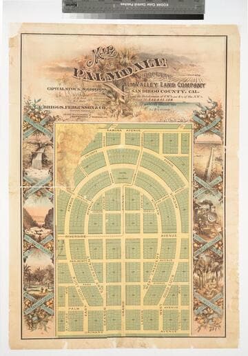
Map of Palmdale : property of the Palm Valley Land Company, San Diego County, Cal. / Surveyed January 1888 by H. J. Stevenson
Rare Books
The projected town of Palmdale, three miles east of Palm Springs, in a portion of San Diego County which later became part of Riverside County, eventually vanished--Cf. P.T. Hann... Dict. Calif. land names. "Subdivision of S.W. 1/4 and S. 1/2 of the N.W. 1/4 of Section 25.T.4 S.R. 4 E. S.B.M." Vignettes: Lush tropical growth. Prime meridian: GM. Relief: hachures. Graphic Scale: Feet. Projection: Plane. Printing Process: Lithography. Verso Text: Stamp: 9395 MS Notes: Palmdale 1888, San Diego Co. 471218.
471218
![Map of the City of Los Angeles: [showing weight of rails laid]](/_next/image?url=https%3A%2F%2Frail.huntington.org%2FIIIF3%2FImage%2F22APN4635XVA%2Ffull%2F%5E360%2C%2F0%2Fdefault.jpg&w=750&q=75)
Map of the City of Los Angeles: [showing weight of rails laid]
Rare Books
Shows streets and prospective electric streetcar lines in red and black. Probably dates before 1903 as the rail lines are not named. Legend gives weights of rails laid. Covers the city of Los Angeles with the Los Angeles Country Club to the West, Slauson Ave. to the South, the Evergreen Cemetery in Boyle Heights to the East, and Elysian Park to the North. "H.E.H." are the initials of Henry E. Huntington, who owned the Pacific Electric Railway Company. Scale statement on map reads "1320 feet to one inch." Coordinates not present on map, approximated from Google maps. Relief given in hachures. Provenance unknown, in library as of 2017. Appears to have come from the office of one of Henry E. Huntington's railway companies.
646649
Image not available
Photographs of track laying for the Los Angeles Cable Railway in Boyle Heights and other views in Los Angeles
Visual Materials
Various cabinet card photographs of Los Angeles, including a series of four images showing digging and laying track for the First Street cable railway in central Los Angeles (Boyle Heights), 1880s. Other photographs in this folder: Grounds of J. M. Workman, Boyle Heights; panoramic view of Los Angeles from the road to San Gabriel by Carleton Watkins; view of Los Angeles Railway Company car on Fifth Street, Los Angeles; Ostrich Farm; image of various Native American water baskets, taken by photographer Jarvis, Pasadena, California.
photPF 610-619