Rare Books
Sectional Map of Colfax and Mora Counties, New Mexico : compiled from the original plats in the Surveyor General's Office at Santa Fe, New Mexico, and from private surveys by the Maxwell Land Grant Company
You might also be interested in
Image not available
Sectional Map of Colfax and Mora Counties, New Mexico : Compiled from the original plats in the Surveyor General's office at Santa Fe, New Mexico and from private surveys by the Maxwell Land Grant Company
Rare Books
Prime meridian: GM. Relief: hachures. Graphic Scale: Miles. Projection: Cylindrical. Printing Process: Lithography.
308408
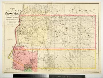
Sectional and Topographical Map of Colfax and Mora Counties Territory of New Mexico
Rare Books
Numerous changes have been made since the earlier map, 128069. "Compiled from the Original Plats in the Surveyor Generals Office Santa Fe, New Mexico. J. S. Taylor U. S. Deputy Surveyor, 1881." "Entered according to Act of Congress in the year 1882 by G.W. & C.B. Colton & Co. in the Office of the Librarian of Congress, at Washington." Prime meridian: GM. Relief: hachures. Graphic Scale: Miles. Projection: Cylindrical. Printing Process: Lithography. Verso Text: HL sticker: 128313.
128313
Image not available
The official map of Orange County California and portions of adjoining counties : compiled from official and private surveys
Rare Books
A detailed map of Orange County before massive development. The northwest corner of the colored border section states, "Boundary line of the Irvine Subdivision." The colored bordered section comprises the Irvine Ranch. Prime meridian: GM. Relief: hachures. Graphic Scale: Feet. Projection: Cylindrical. Printing Process: Lithography. Verso Text: MS note: 435187.
436187
Image not available
Denny's pocket map of Kings County, California : compiled from latest official and private data
Rare Books
Kings County is dominated by Tulare Lake. Prime meridian: GM. Relief: hachures. Graphic Scale: Miles. Projection: Cylindrical. Printing Process: Blue line print.
402172
Image not available
Gold Placers of Upper Snake River with its tributaries : compiled from authentic public and private surveys / by Edmund Wilkes, Civil Engineer, U.S. Deputy Min. Surveyor
Rare Books
Alt. title from cover. Area south of Pocatello. Prime meridian: GM. Relief: hachures. Graphic Scale: Miles. Projection: Cylindrical. Printing Process: Lithography.
42008
Image not available
Topographical map of Wisconsin Territory : compiled from the public surveys, on file in the Surveyor General's office ; / by Samuel Morrison, Elisha Dwelle ; Joshua Hathaway
Rare Books
Territory south of the Wisconsin River. "I certify that this Map is faithfully reduced from the original plats of the Public Surveys on file in this office. Robt. T. Lyle, Surveyor General, Cincinnati April 1st, 1837." Prime meridian: GM. Relief: hachures. Graphic Scale: Miles. Projection: Cylindrical. Printing Process: Lithography.
377199