Visual Materials
Plan du Port de Gouadaquini now called Jekil Sound in the Province of Georgia in North America, Latitude 31:13 North
You might also be interested in

Plan of Port Royal Harbor in Carolina with the Proposed Forts, Depth of Water, &c. Latitude 32D-6 North. According to an Origenal (sic) Draught by H. Moll
Visual Materials
Kashnor notes, "A scarce map locating the fort at Helena Island." Worm holes indicate this map came from the same volume as 093:360S. See 093:379S for another copy. MS note: 5, upper right. Ms note: 378 (on backing). Relief: no. Graphic Scale: Miles. Projection: Plane. Printing Process: Copper engraving. Verso Text: Ms note: 378 (on backing).
093:378 S

Plan of Port Antonio, on the North-East Side of Jamaica
Visual Materials
"The Fort in 18° 19' North Latitude, 75° 23' Longitude W. from London." Kashnor notes, "There is no imprint or engraver, but it was probably issued for use of vessels during Admiral Vernon's expedition in 1741. It shows Fort George, and locates a careening place on Navy Island." Kashnor dates as ca. 1741. Note MS map of Boston harbor on the verso of this map. MS note: 804 (on backing). Prime meridian: London. Relief: pictorial. Projection: Plane. Watermark: EAR. Printing Process: Copper engraving. Verso Text: MS map of Boston Harbor of a similar date. The map has been torn and repaired with a piece laid over the center of the hand drawn map.
093:804 S

Plan of Port Royal Harbor in Carolina with the Proposed Forts, Depth of Water, &c. Latitude 32D-6 North. According to an Original Draught by H. Moll
Visual Materials
Kashnor notes, "A scarce map locating the fort at Helena Island." See 093:378 for another copy. No worn holes in this copy. Ms note: 379 (on backing). Relief: no. Graphic Scale: Miles. Projection: Plane. Printing Process: Copper engraving. Verso Text: Ms note: 379 (on backing).
093:379 S

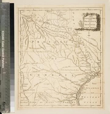
A new and accurate map of the province of Georgia in North America
Visual Materials
Kashnor notes, "Shows the old trading paths and the Hunting Grounds of the Cherokees." Kashnor dates c.1776. RLIN record notes date as [1779?] and place of publication as [London?] and as appearing in The Universal Magazine of 1779. See 093:391 and 105:103 for additional copies. MS note: 94 (on backing). Prime meridian: [Ferro]. Relief: pictorial. Projection: Cylindrical. Watermark: Crowned circular seal. Printing Process: Copper engraving. Other Features: Cartouche. Verso Text: MS note: 32 94(on backing).
093:094 S

New and Accurate Map of the Chief Parts of South Carolina, and Georgia, From the Best Authorities
Visual Materials
Kashnor notes, "Published during the Revolution, this map shows the main roads in both provinces." This map duplicates 093:075S. Map is trimmed to neatline all sides. District and Township lines marked. MS note: 76 (on backing). Prime meridian: London. Relief: no. Graphic Scale: Miles. Projection: Cylindrical. Printing Process: Copper engraving. Verso Text: MS note: 76 (on backing).
093:076 S
![Plan de la Radde du Cap Francois. [Manuscript map]](/_next/image?url=https%3A%2F%2Frail.huntington.org%2FIIIF3%2FImage%2F22APN4KVJXQL%2Ffull%2F%5E360%2C%2F0%2Fdefault.jpg&w=750&q=75)
Plan de la Radde du Cap Francois. [Manuscript map]
Visual Materials
Kashnor notes, "The plan shows all the soundings, with the following prominent places located: La Bourg, Embarcadaire, Isles Noyes, Fort Vieil and Fort le Point. This was evidently drawn by the same hand as the following drawing [093:787]. Kashnor dates as ca. 1760. Kashnor suggests it was drawn by "a French Engineer." MS note: 786 (on backing). Relief: no. Graphic Scale: Leagues. Projection: Plane. Verso Text: MS note: 786 (on backing).
093:786 M