Rare Books
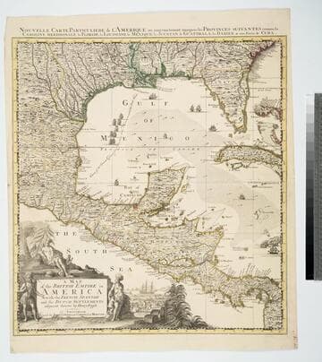
A Map of the British Empire in America with the French Spanish and the Dutch Settlements adjacent thereto/ By Henry Popple. at Amsterdam
You might also be interested in
Image not available
Map of the British Empire in America with the French and Spanish Settlements adjacent thereto by Hen. Popple
Visual Materials
Kashnor notes, "This is Popple's key map, with the rare inset view of New York. It is seldom that a colored copy occurs for sale." Kashnor dates as [1733]. Rosenthal confirms this as the index map for the 20 sheet Popple Atlas map published in 1733. Contain a quote from Edmond Halley praising Popple's map, several views. "Price 2 Shills." "W. H. Toms sculp." "To the Queen's most Excellent Majesty This Map is most humbly inscribed by Your Majesty's most Obedient and Most Humble Servant Henry Popple." Cartouche: Indians. Vignettes: Niagra Falls, Mexico City, Quebec City, New York City. Ships & sea battle. Submaps: Seventeen thumbnail maps of ports.. Prime meridian: London. Relief: pictorial. Projection: Mercator. Printing Process: Copper engraving. Other Features: CartoucheVignettesSub-maps. Verso Text: MS note: 583.
105:583 M
Map of the British Empire in America With the French, Spanish and the Dutch Settlements adjacent thereto by Henry Popple
Visual Materials
Kashnor notes, "Copied from Popple's map With the titles in English and French. ShoWs Carolina divided into counites, With Georgia and the Forts neWly erected, and Savannah." Kashnor dates as ca. 1740, RLIN record suggests 1755. Cartouche of Indians, traders. MS note: No. 10. Relief: pictorial. Projection: Cylindrical. Printing Process: Copper engraving. Other Features: Cartouche. References: McCorkle [741.2]. Verso Text: MS note: 326.
105:326 M

Map of the British Empire in America with the French and Spanish Settlements adjacent thereto by Henry Popple
Visual Materials
Four views and seventeen harbor submaps. Kashnor dates as 1734, other sources mention 1733. Views: Niagara Falls; Mexico [probably Vera Cruz]; Quebec; New York. Submaps: Seventeen small harbor and island maps along right edge.. Prime meridian: London. Relief: pictorial. Projection: Mercator. Printing Process: Copper engraving. Other Features: CartoucheVignettesSub-maps. References: Schwartz pl. 80.. Verso Text: MS note: 474.
093:474 M
Image not available
A map of the British Empire in America, with the French and Spanish settlements adjacent thereto
Rare Books
762151
Image not available
A map of the British Empire in America with the French and Spanish settlements adjacent thereto
Rare Books
130465
Image not available
A map of the British Empire in America, with the French and Spanish settlements adjacent thereto
Rare Books
41661