Rare Books
Bowles's new one sheet map of the United Kingdom of Great Britain and Ireland : delineated from the latest surveys
You might also be interested in
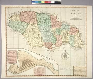
Bowles's New One-Sheet Map of Jamaica, Divided into its Parishes, &c. from the Actual Surveys of Sheffield and others
Visual Materials
Submap: General plan of Port Royal [showing before and after earthquake dimensions].. Prime meridian: London. Relief: pictorial. Graphic Scale: Miles. Projection: Cylindrical. Printing Process: Copper engraving. Other Features: Sub-maps. Verso Text: MS note: 788.
093:788 M
Image not available
Bowles's New One-Sheet Map of the United States of America: with the Territories belonging to Great Britain and Spain
Visual Materials
Kashnor notes, "Ohio, Michigan, Illinois, Wisconsin and Minnesota of today were all comprised in the Western Territory, which is shown reaching to the Lake of the Woods, Chicago is located, and the State of Indiana is shown to be about 60 miles long and broad, situated below Ohio." Kashnor dates as ca. 1798. McCorkle dates as 1795. Cartouche: two maidens. . Prime meridian: London, Ferro. Relief: pictorial. Graphic Scale: Miles. Projection: Pseudocylindrical. Printing Process: Copper engraving. Other Features: Cartouche. References: McCorkle 791.1, 768.1(original). Verso Text: MS note: 513.
093:513 M
Image not available
A Map of New England and Nova Scotia; with parts of New York, Canada, and New Britain & the adjacent islands of New Found Land, Cape Breton, &c
Rare Books
Cartouche: Trees and harbor MS note: 923. "By Tho. Kitchin Geogr." Prime meridian: London. Relief: pictorial. Graphic Scale: Miles. Projection: Conic. Watermark: Two seals. Printing Process: Copper engraving. Other Features: Cartouche. Verso Text: MS note: 150237.
150237

West Indies
Visual Materials
Kashnor notes, "Engraving representing sugar being embarked." Kashnor dates as [1760]. Cartouche: Traders & slave MS note: 976 (on backing).. Prime meridian: London. Relief: pictorial. Graphic Scale: Miles. Projection: Conic. Printing Process: Copper engraving. Other Features: Cartouche.
105:976 S
Image not available
A New and Accurate Map of Quebec and its Boundaries; from a late Survey
Rare Books
Cartouche: minimal floral. MS note: 925. Prime meridian: London. Relief: pictorial. Graphic Scale: Miles. Projection: Pseudocylindrical. Watermark: Two seals. Printing Process: Copper engraving. Other Features: Cartouche. Verso Text: MS note: 150247.
150247
Image not available
Bowles's new travelling map of England and Wales : exhibiting all the direct and principal cross roads ; with the distances in measured miles
Rare Books
Cartouche: Horse and vehicle. Prime meridian: London. Relief: no. Graphic Scale: Miles. Projection: Polyconic. Printing Process: Copper engraving. Other Features: Cartouche. Verso Text: MS notes: 474651 A B C D.
474651