Rare Books
Colton's map of the Pacific States, California and Oregon, with the territories of Nevada, Utah, New Mexico, Colorado & Washington in connection with British Columbia &c., from the latest and best information
You might also be interested in
Image not available
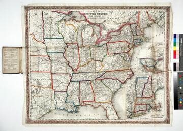
Colton's New Railroad & County Map of the United States The Canadas &c
Rare Books
Alt. title on cover. Submaps: Southern End of Florida; Colton's Map of the United States showing the Proposed Railroad Routes to the Pacific Ocean. Prime meridian: GM, Washington. Relief: hachures. Graphic Scale: Miles. Projection: Polyconic. Printing Process: Lithography.
254732
Image not available
Oregon, Washington, California, Utah & New Mexico
Rare Books
The western United States before Nevada with Arizona Territory encompassing only the Gadsden Purchase ; other states extend much further eastward than today's boundaries. May have been extracted from the 1858 edition of Colton's General Atlas. Border: flowered Submap: Vicinity of San Francisco. MS note: 1859. Prime meridian: GM, Washington. Relief: hachures. Projection: Cylindrical. Printing Process: Lithography. Verso Text: MS note: 252068.
252068
Colton's map of the United States, the Canadas &c showing the rail roads, canals & stage roads with distances from place to place
Rare Books
Kirkpatrick Catalogue entry: "2463 Colton, J. H., publisher. Colton's map of the United States, the Canadas &c. showing the rail roads, canals, & stage roads ... New York, J. H. Colton, 1860. 1 sheet. [see p.]."Alternate title from cover. Submaps: Map of New England and Eastern New York; Map of the United States & Central America; The Isthmus of Panama showing the Routes of Travel between Aspinwall & Panama. . Prime meridian: GM, Washington. Relief: hachures. Graphic Scale: Miles. Projection: Polyconic. Printing Process: Lithography. Other Features: Sub-maps. Verso Text: MS note: R.B. 11486, i Stamp: Kensington Public Libraries.
623637
Image not available
New Map of the State of California, the Territories of Oregon, Washington, Utah & New Mexico
Rare Books
Argosy Book Store San Francisco sold this map to the Huntington. An attached note indicates this map may be the first map to show Arizona. It is shown as "Proposed Arazonia Territory" in the area of the Gadsden Purchase. Border: Typical Mitchell vined border. Prime meridian: GM, Washington. Relief: hachures. Graphic Scale: Miles. Projection: Pseudocylindrical. Printing Process: Lithography.
249161
Image not available
Colton's Territories of New Mexico and Utah
Rare Books
Lower section of New Mexico is labeled "Arizona" in lightly printed letters. MS notes: J. H. Colton 256906 Border: Chained. Prime meridian: GM, Washington. Relief: hachures. Projection: Pseudocylindrical. Printing Process: Lithography. Verso Text: The State of California. descriptive information.
256906

Map of the New York Central and Hudson River Rail Road and its principal connections
Visual Materials
Image of a map of a portion of the Eastern and Midwestern United States from as far west as Omaha, Nebraska, to the Atlantic Ocean, showing the railroad routes of the New York Central and Hudson River Railroad and connecting lines, with a vignette of the seal of New York with the banner "Excelsior" above the map title; map verso contains fold-up map cover with a vignette of a passenger train car labeled "Wagners Palace Drawing Room Car" and panels with promotional descriptions and timetables.
priJLC_TRAN_001171