Rare Books
A New and Accurate Map of Mexico or New Spain together with California New Mexico &c
You might also be interested in
Image not available
New and Accurate Map of Mexico or New Spain together with California New Mexico &c. Drawn from the best Modern Maps & Charts & Regulated by Astronl. Observns. by Eman. Bowen. No. 110 lower left
Visual Materials
Kashnor notes, "Contains the following note, 'California, which has been Described and Represented as an island, even by very modern Geographers, was discovered by Father Eusebius Francis Kino, a Jesuit, to be a peninsula between the years 1698 and 1701." Cartouche cut "shewing a Spaniard ill-treating two Indians." Submap of Gallapagos Islands. Submap: The Gallapagos Islands Discovered & Described by Capt. Cowley in 1684.. Prime meridian: London. Relief: pictorial. Graphic Scale: Leagues. Projection: Conic. Printing Process: Copper engraving. Other Features: Sub-maps. Verso Text: MS notes: Cat. 105 253.
105:253 M
Image not available
A New and Accurate Map of Peru, and the country of the Amazones
Visual Materials
Kashnor notes, "Indicates Parima Lake and the famour city of El Dorado two degrees North of the Equator." Kashnor dates as ca. 1760. RLIN record suggests 1747 as publication data. Cartouche: Decorative shell.. "Drawn from the most authentick French Maps &c. and Regulated by Astronomical Observations. By Eman. Bowen." "No. 118 (lower left)" Prime meridian: London. Relief: pictorial. Graphic Scale: Leagues. Projection: Pseudocylindrical. Printing Process: Copper engraving. Other Features: Cartouche. Verso Text: MS note: 933.
105:933 M
Image not available
A New and Accurate Map of the Islands of Newfoundland, Cape Briton, St. John and Anticosta; together with the neighboring Countries of Nova Scotia, Canada &c
Visual Materials
"Drawn from the most approved Modern Maps and Charts, and Regulated by Astront. Observatns. by Eman Bowen." Variant of 093:262. Kashnor dates as ca. 1752. Kershaw identifies this as the first state of Bowen's map, published in 1747. Prime meridian: London. Relief: pictorial. Graphic Scale: Miles. Projection: Pseudocylindrical. Printing Process: Copper engraving. Other Features: Cartouche. References: Kershaw 693; LC Phillips 603. Verso Text: MS note: 561.
105:561 M
Image not available
A New and Accurate Map of Paraguay, Rio de la Plata, Tucumania Guaria &c
Visual Materials
Kashnor notes, "Shows a note on the Jesuit settlement in Paraguay, said to contain about 300,000 families." Kashnor dates as ca. 1760. RLIN record suggests a date of 1747. Cartouche: Indians and traders.. "Laid down from the latest Improvements, and Regulated by Astronomical Observations, by Eman Bowen." "No. 127 (lower left)" Prime meridian: London. Relief: pictorial. Graphic Scale: Miles. Projection: Azimuthal. Printing Process: Copper engraving. Other Features: Cartouche. Verso Text: MS note: 926.
105:926 M
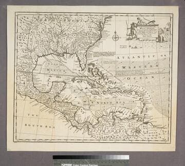
An Accurate Map of the West Indies
Visual Materials
Kashnor notes, "Includes Florida, Georgia, Carolina, Virginia, and Maryland. Also shows the coast of New Leon and present-day Texas." Kashnor dates as ca. 1767. RLIN record suggests 1747. Cartouche: Natives & Lion.. "Drawn from the best Authorities, assisted by the most approved Modern Maps and Charts, and regulated by Astronomical Observations. By Eman. Bowen." Prime meridian: London. Relief: pictorial. Graphic Scale: Miles. Projection: Azimuthal. Printing Process: Copper engraving. Other Features: Cartouche. Verso Text: MS note:943.
105:943 S
Image not available
A New and Accurate Map of Chili, Terra Magellanica, Terra del Fuego &c
Visual Materials
Kashnor dates as ca. 1730. Two submaps and text. Cartouche: framed. Submaps: Plan of the City of Saint Jago Capital of the Kingdom of Chili; Chart of the Extreme Part of South America in which is contained the Islands discovered by the Ships of St. Malo since 1700,... "Laid down according to the latest Improvements and Regulated by Astronl. Observatns. By Eman:Bowen." "No. 127 (lower left)" Prime meridian: London. Relief: pictorial. Graphic Scale: Leagues. Projection: Pseudocylindrical. Printing Process: Copper engraving. Other Features: CartoucheSub-maps. Verso Text: MS note: 909.
105:909 M