Rare Books
An accurate map of Canada, with the adjacent countries : exhibiting the late seat of war between the English & French in those parts
You might also be interested in
Image not available
A new and accurate map of the present seat of the war in North America
Rare Books
New England extends to the St. Lawrence River, New York extends across present day Ontario. Mat sticker: 546 MS notes on mat: 150044. "G. Rollos sculp." Prime meridian: London. Relief: pictorial. Projection: Azimuthal. Printing Process: Copper engraving.
150044
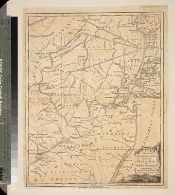
New and Accurate Map of the Present Seat of War in North America, Comprehending New Jersey, Philadelphia, Pensylvania (sic), New-York &c
Visual Materials
Kashnor dates as c.1770. Probably later because of reference to Revolutionary War. Some notes regarding boundary dispute between New York and New Jersey. Small vined cartouche with sailing ship. MS note: 101 (on backing). Prime meridian: London. Relief: pictorial. Graphic Scale: Miles, statute. Projection: Cylindrical. Watermark: Crowned seal. Printing Process: Copper engraving. Other Features: Cartouche. Verso Text: MS note: 410 (map) 101 (on backing).
093:101 S
Image not available
Accurate Map of Louisiana, and the Territory in Dispute between the English & French
Visual Materials
Kashnor notes, "Includes parts of Virginia, North and South Carolina, Georgia and Florida." Kashnor dates as ca. 1755. RLIN record suggests 1761. RLIN record covers a photocopy but is included to add data of appeared in information. MS note: 421 (on backing). Prime meridian: London. Relief: pictorial. Graphic Scale: Miles. Projection: Pseudocylindrical. Printing Process: Copper engraving. Verso Text: MS note: 421 (on backing).
093:421 S
Image not available
New and Accurate Map of Louisiana, with Part of Florida and Canada, and the Adjacent Countries, Drawn from Surveys, assisted by the most approved English & French Maps & Charts. The whole being regulated by Astronl. Observations, by Eman. Bowen
Visual Materials
Kashnor notes, "This shows the boundaires of Louisiana according to the French claims which led to war. It is a good map of the Illinois country, locates Chicago, also of New Mexico, with the location of Santa Fe, Taos, and other towns." Kashnor dates ca. 1745, RLIN record suggests 1745. Cartouche: with Indian.. Prime meridian: London. Relief: pictorial. Graphic Scale: Leagues. Projection: Pseudocylindrical. Watermark: Fluer-di-lis V(?) A G. Printing Process: Copper engraving. Other Features: Cartouche. References: Wheat cv.1, no.122.
093:433 M