Rare Books
Spanish North America
You might also be interested in
Image not available
America
Visual Materials
Kashnor notes, "Shows all the old Spanish settlements in California, locating San Francisco, Santa Cruz, Monterey, San Antonio, San Gabriel, and San Miguel." Prime meridian: GM. Relief: pictorial. Projection: Azimuthal. Printing Process: Engraving. Verso Text: MS note: 281.
105:281 M
Image not available
America [North and South in two sheets]
Visual Materials
Kashnor notes, "Locates San Francisco, Monterey, San Gabriel and San Diego in California, and also shows all the country north of the Californian border coloured green as part of the United States. It locates Columbia River with Clark's and Lewis's branches, also the Frazer River." Shows Pacific Islands to New Zealand, west coast of Africa. Prime meridian: GM. Relief: hachures. Projection: Azimuthal. Printing Process: Engraving. Verso Text: MS notes: North America 58 North America 59 282/105 (upper sheet) South America 60 South America 61 (lower sheet) .
105:282 M
Image not available
America
Visual Materials
Kashnor notes, "Shows a good map of the North-West, locating San Francisco, Monterey, Santa Cruz, San Gabriel, Columbia River, &c." Prime meridian: GM. Relief: pictorial. Projection: Pseudocylindrical. Printing Process: Engraving. Verso Text: Ms notes: Cat 105 201.
105:201 M
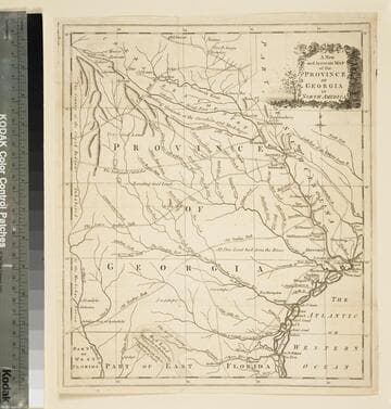
A new and accurate map of the province of Georgia in North America
Visual Materials
Kashnor notes," An old map published about 1775, shewing the roads and Indian paths." Kashnor dates c.1775. Duplicate map to 093:094S, 093:391. RLIN record notes date as [1779?] and place of publication as [London?] and as appearing in The Universal Magazine of 1779. MS note: 103 (on backing). Prime meridian: [Ferro]. Relief: pictorial. Projection: Cylindrical. Watermark: Crowned circular seal. Printing Process: Copper engraving.
105:103 S
Image not available
America septentrionalis novissima ; America meridionalis accuratissima / P. Schenk ex: Amsteloed; cum Privil
Visual Materials
Kashnor notes, "California is shown as an island, locating Drake's Port and Port of Monterey, also Taos and Santa Fe in New Mexico." Kashnor dates as ca. 1700. McLaughlin dates as [1695] and gives appeared in data. Burden dates as 1696. For other copy see 150219; for later version see 093:149. Two cartouches with figures. Prime meridian: Ferro. Relief: pictorial. Projection: Pseudocylindrical. Watermark: L ?. Printing Process: Copper engraving. References: McLaughlin 120; Tooley 56; Leighly 102; Koeman III, p.119 (11); Burden, map 722 Verso Text: MS note: 155.
093:155 M
Image not available
A New Map of North America Shewing its Principal Divisions, Chief Cities, Townes, Rivers, Mountains &c
Rare Books
Kashnor notes, "Shows California as an island and locates New Albion of Sr. Francis Drake; also shows New Mexico, locating Santa Fe." McLaughlin identifies this as state 4 of this map, printed 1704 or later and gives appeared in information. See 105:268 Museum Bookstore Collection for another copy. This is the missing 093:197 from Museum Bookstore Collection. "Dedicated to His Highness William Duke of Glocester." "Delin. MBurg. sculpt. Univ. Oxon" Prime meridian: London. Relief: pictorial. Projection: Pseudocylindrical. Printing Process: Copper engraving. References: McLaughlin 142; Wagner 466; Tooley 69 (Plate 53); Leighly 116 (Plate XXII, State 4) . Verso Text: MS notes: 39 197 139314 Cat 93 197.
139314