Rare Books
Group map of the Tom Reed Gold Road District Mohave County Arizona / Compiled from personal surveys, official records and other reliable sources, by Haff & Colwell, U.S. mining surveyors

You might also be interested in
Image not available
Map of California / Compiled from official and authentic sources by the Southern Pacific Lines
Rare Books
Verso shows 200M printed 8-27-10. Alt. title from verso. Gift of Mrs. Bertha Anthony October, 1944. Submap: Bay Area; Temperature chart. Prime meridian: GM. Relief: hachures. Graphic Scale: Miles. Projection: Cylindrical. Printing Process: Lithography. Verso Text: Sales pitch for California. .
254841
Image not available
Ide's map of Helena Montana 1890 : compiled and drawn from official sources and the county records / compiled and drawn by Reeder & Helmick, Surveyors & Draughtsmen Helena, Mon
Rare Books
Three separate rail roads run parallel to one another through the center of town. MS note: 349374. Prime meridian: GM. Relief: no. Graphic Scale: Feet. Projection: Plane. Printing Process: Lithography.
349374
Image not available
Map of Tonopah Mining District, Nevada
Rare Books
Gift of Hugh Tolford 12/80. Submaps: various sub districts. Prime meridian: GM. Relief: hachures. Graphic Scale: Feet. Projection: Plane. Printing Process: Lithography.
475732
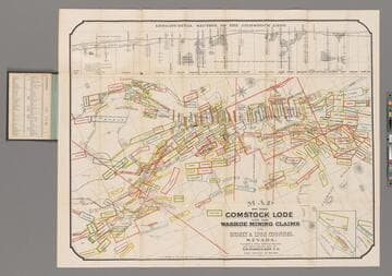
Map of the Comstock Lode and the Washoe Mining Claims in Storey & Lyon Counties, Nevada / Compiled from Official Surveys and other reliable data by T. D. Parkinson, C.E
Rare Books
Longitudinal Section of the Comstock Lode. Prime meridian: GM. Relief: hachures. Graphic Scale: Feet. Projection: Plane. Printing Process: Lithography. Verso Text: MS note: 240738.
240738
Image not available
Map of the Mining Claims adjoining Leadville situate in California Mining District ; Lake County, Colorado Carefully compiled & drawn from official surveys & records / By Edward Rollandet, Denver, Colo
Rare Books
Alt. title from cover. Prime meridian: Gm. Relief: no. Graphic Scale: Feet. Projection: Plane. Printing Process: Lithography.
306956
Image not available
Heald-Menerey's New Authentic Map of Portland : Compiled from the Official Records of Multnomah County, the City of Portland, U.S. Engineer
Rare Books
Street Index, Churches, Public Buildings, Docks, Warehouses. Location tables.. Prime meridian: GM. Relief: no. Graphic Scale: Feet. Projection: Plane. Printing Process: Lithography.
269472