Opening Hours
Daily: 10 A.M.–5 P.M.
Closed on Tuesdays
1151 Oxford Road
San Marino, CA 91108
Rare Books
Daily: 10 A.M.–5 P.M.
Closed on Tuesdays
1151 Oxford Road
San Marino, CA 91108

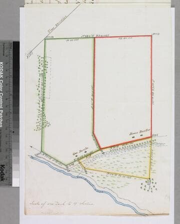
Manuscripts
Bound within survey field notes document - Durfee brothers tracts - similar to previous maps in this folder, but more surface detail: vegetation, swamp lands along San Gabriel River. Alt. title supplied by cataloger.
mssSolano SR_Box_22(01).03
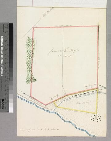
Manuscripts
Copy of previous map on paper, Bound within survey field notes document - Durfee brothers tracts - similar to previous maps in this folder, but more surface detail: vegetation, swamp lands along San Gabriel River. Alt. title supplied by cataloger.
mssSolano SR_Box_22(01).04
Image not available
Manuscripts
The collection consists of maps, field books, legal documents, business papers, and diaries related to the work of surveyors George Hansen, Alfred Solano, Sidney B. Reeve, and others. The maps and surveys in the collection are of the city of Los Angeles, Southern California ranchos, and subdivisions of the city of Los Angeles and neighboring towns. The collection contains over maps and sketch maps. Other subjects represented in the collection include: civil engineering, land subdivision, mines and mineral resources, and daily life in Los Angeles and Los Angeles County.
mssSolano
Image not available
Manuscripts
Collection of maps surveyed for the Los Angeles County Assessor's Office between 1860 and 1897. The maps primarily focus on excavations, improvements, and expansions of roads throughout Los Angeles, San Bernardino, and Orange Counties, with geographic coverage ranging from Malibu to Pomona and Newhall to San Juan Capistrano. Most of the maps show boundary lines of the various Ranchos existent throughout these counties, and many also include buildings, railroads, telegraph lines, land use, relief, and elements of the natural landscape such as canyons and rivers. Also included are maps showing the San Gabriel Mission, San Juan Capistrano Mission, and an elevation of the Los Angeles County court house. Some of the Ranchos depicted include San Antonio, Azusa, San Jose, Los Nogales, San Pedro, San Joaquin, San Rafael, Centinela, La Puente, Sausal Redondo, La Ballona, Rodeo-de-las-Aguas, Cienega, San Pasqual, and San Francisquito. Property shown includes that of Elias 'Lucky' Baldwin, Pio Pico, and Abel Stearns. The maps were originally housed in 16 bound volumes.
LARM_Vol_15_02.01
Image not available
Rare Books
"Note: For convenience in subdividing and plotting the nomenclature of the govrnment [sic] surveys has been adopted and the township range and section lines projected; but this survey is altogether independent of the government surveys. All roads and avenues on this map are 60 feet wide." Hand colored map from current day Chatsworth to west beyond Moorpark. Taped edges on all sides. M
384611
Image not available
Manuscripts
The collection consists of maps, field books, legal documents, business papers, and diaries related to the work of surveyors George Hansen, Alfred Solano, Sidney B. Reeve, and others. The maps and surveys in the collection are of the city of Los Angeles, Southern California ranchos, and subdivisions of the city of Los Angeles and neighboring towns. The collection contains over maps and sketch maps. Other subjects represented in the collection include: civil engineering, land subdivision, mines and mineral resources, and daily life in Los Angeles and Los Angeles County.
mssSolano