Visual Materials
A Chart of the Windward Passage between the Islands of Jamaica Hispaniola and Cuba with the Other Passages to the Northward of Hispaniola

You might also be interested in

Chart of the Island of Hispaniola With the Windward passage from Jamaica between the East end of Cuba & the West end of Hispaniola
Visual Materials
Kashnor identifies the author as J. Thornton and dates as ca. 1680. MS note: 782 (on backing). Relief: no. Graphic Scale: Leagues. Projection: Cylindrical. Printing Process: Copper engraving. Verso Text: MS note: 782 (on backing).
093:782 M

A Chart of the Gulf of Florida or New Bahama Channel, Commonly called the Gulf Passage, between Florida, the Isle of Cuba, & the Bahama Islandes: From the Journals, Observations and Draughts of Mr. Chas. Roberts, Master of the Rl. Navy, Compared with the Surveys of Mr. George Gauld &ca
Visual Materials
Table of longitude and latitude for principal points on the map. Comments on Gulf Stream temperature differences. Submap: The islands and Kays from Booby Rocks to Hog Island (New Providence Island). Vignettes: Seven views of island profiles.. Prime meridian: GM. Relief: hachures. Projection: Cylindrical. Printing Process: Copper engraving. Other Features: Sub-mapsVignettes. Verso Text: MS notes: 391 4.
105:391 M

A Correct Chart of Hispaniola with the Windward Passage Humbly Dedicated to Mr. John Machin Professor of Astronomy at Gresham Colledge by C. Price Hydrographer to the King
Visual Materials
Relief: pictorial. Graphic Scale: Leagues. Projection: Cylindrical. Printing Process: Copper engraving. Verso Text: MS note: 417.
105:417 M
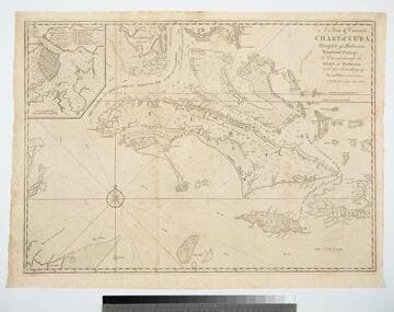
A New & Correct Chart of Cuba, Streights of Bahama, Windward Passage, the Current through the Gulf of Florida, with the Soundings &c. By an Officer in the Navy
Visual Materials
Kashnor dates as ca. 1740. Sub-map: A Plan of the Harbour & Town of Havana. Prime meridian: London. Relief: pictorial. Projection: Mercator. Printing Process: Copper engraving. Other Features: Sub-maps. Verso Text: MS note: 381.
105:381 M
Image not available
A Chart of West Falkland Island
Visual Materials
Contains submap of other Falkland Islands. North is towards bottom of map. "from an Actual Survey by Lieut. Thos. Edgar of the Royal Navy, in the Years 1786 & 1787." "Engraved by T. Foot, Weston Place, Battle Bridge." Submap: Chart of Falkland Islands.. Prime meridian: GM. Relief: hachures. Graphic Scale: Leagues. Projection: Cylindrical. Printing Process: Copper engraving. Other Features: Sub-maps. Verso Text: MS notes: Jn. H. Coleman Falkland Island No. 3 915.
105:915 M

A Chart of the Antilles, or Charibbee, or, Caribs Islands, with the Virgin Isles
Visual Materials
Comparative elevation views of many islands. See also 093:722 for another copy. Submap: Positions Ascertained by Courses and Distances given; on a scale reduced to the Third. Vignettes: Twenty three views of various islands from shipboard for identification purposes.. "By L. S. de la Rochette MDCCLXXXIV. (1784) From the situation of the Caribs Islands, compared with that of the Westernmost Isles of the Mexican Gulf, They are named Windward Islands by the Spaniards, as well as by the French, the Dutch, and the Danes; while the English, who consider the position of those Islands respectively to Barbadoies give them the name Leeward Islands, or Leeward Charibee Islands." "W. Palmer sculp." Prime meridian: London. Relief: hachures. Projection: Cylindrical. Printing Process: Copper engraving. Other Features: Sub-mapsVignettes. Verso Text: MS note: 947.
105:947 M