Visual Materials
This Map of the United Provinces of La Plata, the Banda Oriental, & Chile
You might also be interested in
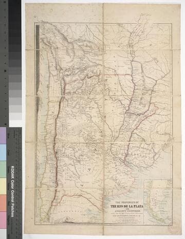
The provinces of the Rio de la Plata and adjacent countries : chiefly from the map constructed / by J. Arrowsmith for Sir Woodbine Parish, K.C.H., drawn by Augustus Petermann
Rare Books
Kirkpatrick Catalogue entry: "2458 d Arrowsmith, J. The provinces of the Rio de la Plata and adjacent countries, chiefly from the map constructed ... for Sir Woodbine Parish ... drawn by Augustus Petermann. [London], A. Petermann, [1850?]. 1 sheet. [see p.]."Includes section views: "Section from Raya Pass to Buenos Ayres through the Peru Bolivian Tablelands, and the Travesia and the Pampas of La Plata" and "Section from Valpraiso to Buenos Ayres." The map by Sir Woodbine Parish, on which this is based, was published in 1852. Martin de Moussy published his Description géographique et statique de la Confédération Argentina after this map, in 1860. (Técnica, política y "deseo territorial" en la cartografía oficial de la Argentina (1852-1941), Carla Lois, Scripta Nova, volume 10, number 218 (52), August 1 2006.) Probably obtained while Burton was in South America between 1865 and 1868. Submap: Section from Raya Pass to Buenos Ayres, through the Peru Bolivian Tablelands and the Traversia and the Pampas of La Plata; Patagonia and Tierra del Fuego. Stamp: Kensington Public Library. MS notes in Paraguay and Brazil.. Prime meridian: GM. Relief: hachures. Graphic Scale: Miles, leagues. Projection: Polyconic. Printing Process: Lithography. Other Features: Sub-maps. Verso Text: Stamp: Kensington Public Library (3).
623632
Image not available
A New and Accurate Map of Paraguay, Rio de la Plata, Tucumania Guaria &c
Visual Materials
Kashnor notes, "Shows a note on the Jesuit settlement in Paraguay, said to contain about 300,000 families." Kashnor dates as ca. 1760. RLIN record suggests a date of 1747. Cartouche: Indians and traders.. "Laid down from the latest Improvements, and Regulated by Astronomical Observations, by Eman Bowen." "No. 127 (lower left)" Prime meridian: London. Relief: pictorial. Graphic Scale: Miles. Projection: Azimuthal. Printing Process: Copper engraving. Other Features: Cartouche. Verso Text: MS note: 926.
105:926 M
Image not available
Provinces of La Plata, the Banda Oriental del Uruguay and Chile, Chiefly from M. S. documents communicated by Sir Woodbine Parish, K.C.H. Late H. M. Charge'd'Affairs &c. at Buenos Ayres. by John Arrowsmith
Visual Materials
Prime meridian: GM. Relief: hachures. Graphic Scale: Miles, leagues. Projection: Pseudocylindrical. Printing Process: Copper engraving. Verso Text: MS note: 640.
093:640 M